1970s Maps of Sawyers Bar, California
Explore 2 historic maps of Sawyers Bar from the 1970s. These maps offer a rare glimpse into what life looked like during the 1970s — showing old roads, neighborhoods, homes, and landmarks that have changed or disappeared over time.
Whether you're researching your family's past, planning a metal detecting trip, or studying how Sawyers Bar's landscape evolved across the 1970s, these high-resolution maps are a powerful tool for exploring the history of this region.
- Focus on a specific era: All maps on this page are from the 1970s, giving you a focused view of this time period.
- See what’s changed: Compare century-old streets, trails, and buildings to today's modern landscape using overlays and satellite layers.
- Research with precision: Use these maps for genealogy, historical research, land use analysis, or educational projects.
- View, download, or print: Maps are fully viewable online in high resolution, and can be downloaded or printed for your own records.
Start exploring Sawyers Bar's history through authentic maps from the 1970s. This is your window into the past.
Sawyers Bar, CA maps
(2)- 1978 Map of Sawyers Bar, 1979 Print
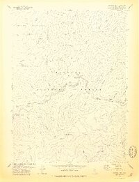 1978 Sawyers Bar1979 Print · USGSThe Salmon River mining district comes into focus in the late 1970s, showing a rugged landscape of deep gulches and remote camps. Genealogists and historians can locate Sawyers Bar, the Bestville (Site), and numerous legacy sites like the Black Bear Mine.
 - 1979 Map of Sawyers Bar
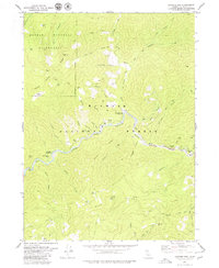 1979 Sawyers Bar1979 Print · USGSThe Salmon River canyon in the late seventies reveals a landscape defined by its mining heritage and isolated ranching outposts. Genealogists and historians can locate the Bestville (Site), trace the Dredge Tailings near Sawyers Bar, and find remote landmarks like Black Bear Mine and Ahlgren Ranch.2 unique versions available
End of results
Showing maps 1-2 of 2
Top cities near Sawyers Bar
Frequently asked questions
- What are the different types of historical maps available for Sawyers Bar?
- What is the oldest map of Sawyers Bar?
- Where can I purchase historical maps of Sawyers Bar for my home or office?
- Where can I download high-res historical maps of Sawyers Bar?
- Are there historical topographic maps available for Sawyers Bar?
- Is there historical aerial imagery available for Sawyers Bar?
- Where are historical maps of Sawyers Bar sourced from?