Old Maps of Seiad Valley, California
Explore 14 old maps of Seiad Valley, spanning from 1914 to today. These high-resolution historic maps reveal how streets, neighborhoods, landmarks, and natural features evolved over time — perfect for genealogy, metal detecting, research, and local history exploration.
What you can do with these maps:
- See how Seiad Valley changed over time: Compare historical maps to modern-day views to trace roads, homesites, rail lines & more.
- View detailed metadata: Each map includes creators, publishers, year, scale, and archive source.
- Overlay maps with satellite & LiDAR: Visualize the past alongside modern tools to explore terrain & human change.
- Trusted historical sources: Maps sourced from the USGS, Library of Congress, and other archives.
- Access maps your way: View online, download high-res files, or order prints for personal or research use.
Start exploring old maps of Seiad Valley to uncover forgotten places, hidden landmarks, and the deep history beneath your feet.
Seiad Valley, CA maps
(14)- 1914 Map of Seiad, 1957 Print
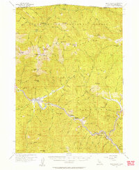
 1914 Seiad1957 Print · USGSSiskiyou County's rugged borderlands are documented here just before the First World War, showing a landscape of remote mines and river settlements. Genealogists and historians can trace family outposts like Johnsons Dairy, old schoolhouses, and active mining works such as the Blue Ledge Mine.
 - 1922 Map of Seiad
 1922 Seiad1922 Print · USGSSiskiyou County's rugged mining and timber country is captured here during the early twentieth century. Researchers can trace historic river crossings like Gordons Ferry, remote schools such as Nolton School, and active gold operations including the Siskiyou Mine.4 unique versions available
 - 1948 Map of Weed, 1950 Print
 1948 Weed1950 Print · USGSNorthern California and Southern Oregon are captured here during the post-war era, documenting the mountain-and-valley economies of the Klamath and Cascade ranges. Trace the legacy of local mining and timber at the King Solomon Mine, find old schools like Siskiyou County School, and follow the historic Southern Pacific RR route.2 unique versions available
 - 1950 Map of Weed
 1950 Weed1950 Print · USGSSiskiyou County and the surrounding Klamath mountains appear in the mid-century before extensive modern development. Genealogists and local historians can locate remote outposts like the Lee Brown Ranch and the specialized settlement of Darlingtonia.
 - 1955 Map of Seiad Valley, 1957 Print
 1955 Seiad Valley1957 Print · USGSSiskiyou County's Klamath River corridor is captured here in the mid-fifties, showing the isolated mining and ranching settlements along the Oregon border. Genealogists and researchers can trace the roads to Seiad Valley, Hamburg, and the remote Blue Ledge Mine.3 unique versions available
 - 1958 Map of Weed, 1963 Print
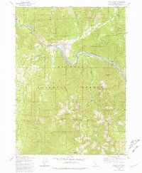
 1958 Weed1963 Print · USGSThe Northern California high country of the late fifties is defined by the towering presence of Mt Shasta and the logging railroads of the Siskiyou range. Genealogists and researchers can trace remote mining sites like the China Mine and mountain settlements such as Sawyers Bar and Seiad Valley.3 unique versions available
 - 1963 Map of Weed
 1963 Weed1963 Print · USGSNorthern California during the early 1960s shows a landscape of steep mountain ranges and river-fed valleys at the height of the timber era. Researchers can trace the routes of the McCloud River RR, locate remote sites like the Holiday Mine, or find ancestral markers at the Scott Valley Cem.
 - 1980 Map of Seiad Valley, 1981 Print
 1980 Seiad Valley1981 Print · USGSThe Klamath River valley comes into focus during the early eighties, showing the settlement of Seiad Valley and the Pacific Crest National Scenic Trail. Trace family-named landmarks like Grider Creek Ranch or the remote Hoags Camp East Fork Walker Creek.2 unique versions available
 - 1983 Map of Happy Camp, 1984 Print
 1983 Happy Camp1984 Print · USGSThe Northern California borderlands and the Klamath River corridor are documented here in the early eighties as a hub of mining and forestry. Researchers can trace historical extraction at the High Plateau Mine and Independence Mine or locate the remote riverside community of Scott Bar.
 - 2001 Map of Seiad Valley, 2004 Print
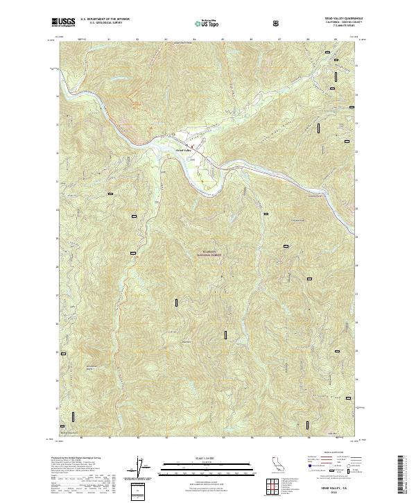
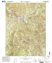 2001 Seiad Valley2004 Print · USGSSiskiyou County's river-and-forest landscape is captured here at the start of the 2000s, centered on the community of Seiad Valley. Researchers can find legacy mining tailings, the Seiad Work Center, and landmarks like Grider Creek Ranch along the water.
 - 2012 Map of Seiad Valley, 2012 Print
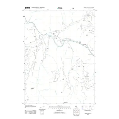 2012 Seiad Valley2012 Print · USGSCovers Seiad Valley, including Siskiyou County, United States, and other nearby areas
 - 2015 Map of Seiad Valley, 2015 Print
 2015 Seiad Valley2015 Print · USGSCovers Seiad Valley, including Siskiyou County, United States, and other nearby areas
 - 2018 Map of Seiad Valley, 2018 Print
 2018 Seiad Valley2018 Print · USGSCovers Seiad Valley, including Siskiyou County, United States, and other nearby areas
 - 2022 Map of Seiad Valley, 2022 Print
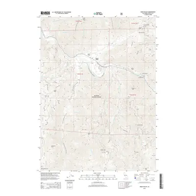
 2022 Seiad Valley2022 Print · USGSSiskiyou County's river-cut interior is documented here in the early 2020s, showing the intersection of the Klamath River and the high mountain ridges. Trace the winding Pacific Crest National Scenic Trl past landmarks like Limestone Bluffs and Johnny O'Neil Ridge.
End of results
Showing maps 1-14 of 14
Frequently asked questions
- What are the different types of historical maps available for Seiad Valley?
- What is the oldest map of Seiad Valley?
- Where can I purchase historical maps of Seiad Valley for my home or office?
- Where can I download high-res historical maps of Seiad Valley?
- Are there historical topographic maps available for Seiad Valley?
- Is there historical aerial imagery available for Seiad Valley?
- Where are historical maps of Seiad Valley sourced from?