1980s Maps of Seiad Valley, California
Explore 2 historic maps of Seiad Valley from the 1980s. These maps offer a rare glimpse into what life looked like during the 1980s — showing old roads, neighborhoods, homes, and landmarks that have changed or disappeared over time.
Whether you're researching your family's past, planning a metal detecting trip, or studying how Seiad Valley's landscape evolved across the 1980s, these high-resolution maps are a powerful tool for exploring the history of this region.
- Focus on a specific era: All maps on this page are from the 1980s, giving you a focused view of this time period.
- See what’s changed: Compare century-old streets, trails, and buildings to today's modern landscape using overlays and satellite layers.
- Research with precision: Use these maps for genealogy, historical research, land use analysis, or educational projects.
- View, download, or print: Maps are fully viewable online in high resolution, and can be downloaded or printed for your own records.
Start exploring Seiad Valley's history through authentic maps from the 1980s. This is your window into the past.
Seiad Valley, CA maps
(2)- 1980 Map of Seiad Valley, 1981 Print
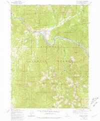 1980 Seiad Valley1981 Print · USGSThe Klamath River valley comes into focus during the early eighties, showing the settlement of Seiad Valley and the Pacific Crest National Scenic Trail. Trace family-named landmarks like Grider Creek Ranch or the remote Hoags Camp East Fork Walker Creek.2 unique versions available
 - 1983 Map of Happy Camp, 1984 Print
 1983 Happy Camp1984 Print · USGSThe Northern California borderlands and the Klamath River corridor are documented here in the early eighties as a hub of mining and forestry. Researchers can trace historical extraction at the High Plateau Mine and Independence Mine or locate the remote riverside community of Scott Bar.
End of results
Showing maps 1-2 of 2
Frequently asked questions
- What are the different types of historical maps available for Seiad Valley?
- What is the oldest map of Seiad Valley?
- Where can I purchase historical maps of Seiad Valley for my home or office?
- Where can I download high-res historical maps of Seiad Valley?
- Are there historical topographic maps available for Seiad Valley?
- Is there historical aerial imagery available for Seiad Valley?
- Where are historical maps of Seiad Valley sourced from?