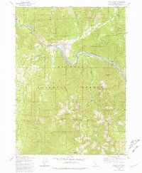
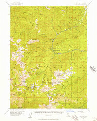
1980 Map of Seiad Valley
USGS Topo · Published 1981About this map
The Klamath River carves through the heart of the Klamath National Forest, defining the valley floor where the community of Seiad Valley sits. In this 1980 survey, the landscape is a mix of protected wilderness and active land management, evidenced by the presence of a Work Center and a Gaging Station along the riverbank. Significant human history is etched into the terrain at Grider Creek Ranch and through the presence of tailings near the river, hinting at the area's gold-mining heritage along the river's gravels. For recreationists and historians, the Pacific Crest National Scenic Trail is clearly delineated as it winds through the mountains. The map tracks dramatic elevation changes from the river's edge up to Lower Devils Peak and the Limestone Bluffs, while numerous drainages like Johnny O'Neil Creek and Walker Creek feed into the central river system.
Find a feature on this map
52 named features on this map. Tap any name to fly to it.
Don’t see what you’re looking for? This feature index may not catch every label — zoom into the map to look around manually.
Map Details
Editions of this 1980 Seiad Valley Map
2 editions found
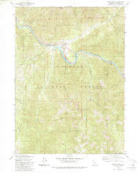
Other maps of this area

1914 · Seiad
USGS Topo · 1:125,000

1922 · Seiad
USGS Topo · 1:125,000

1948 · Weed
USGS Topo · 1:250,000

1950 · Weed
USGS Topo · 1:250,000
1955 · Seiad Valley
USGS Topo · 1:62,500
1955 · Ukonom Lake
USGS Topo · 1:62,500
1955 · Scott Bar
USGS Topo · 1:62,500
1956 · Happy Camp
USGS Topo · 1:62,500

1958 · Weed
USGS Topo · 1:250,000

1963 · Weed
USGS Topo · 1:250,000