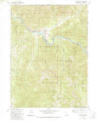
1980 Map of Seiad Valley
USGS Topo · Published 1988About this map
Seiad Valley sits along a northern bend of the Klamath River, serving as a central point of settlement in this remote Siskiyou County landscape. The mapping, based on 1972 aerial photography and 1974 field checks, reveals a topography defined by the confluence of major drainages and agricultural activity at the Grider Creek Ranch. The river dominates the valley floor, fed by significant tributaries like Grider Creek and the East Fork Seiad Creek, which carve through the surrounding high ridges of the Klamath National Forest. This 1980 edition provides a clear record of the small-scale ranching and rural infrastructure that sustained this northern California community in the mid-1970s, before later environmental or land-use changes.
Find a feature on this map
5 named features on this map. Tap any name to fly to it.
Don’t see what you’re looking for? This feature index may not catch every label — zoom into the map to look around manually.
Map Details
Editions of this 1980 Seiad Valley Map
2 editions found
Other maps of this area

1914 · Seiad
USGS Topo · 1:125,000

1922 · Seiad
USGS Topo · 1:125,000

1948 · Weed
USGS Topo · 1:250,000

1950 · Weed
USGS Topo · 1:250,000

1955 · Seiad Valley
USGS Topo · 1:62,500

1955 · Ukonom Lake
USGS Topo · 1:62,500

1955 · Scott Bar
USGS Topo · 1:62,500

1956 · Happy Camp
USGS Topo · 1:62,500

1958 · Weed
USGS Topo · 1:250,000

1963 · Weed
USGS Topo · 1:250,000