Old Maps of Solano County, California
Explore 230 old maps of Solano County, spanning from 1896 to today. These high-resolution historic maps reveal how streets, neighborhoods, landmarks, and natural features evolved over time — perfect for genealogy, metal detecting, research, and local history exploration.
What you can do with these maps:
- See how Solano County changed over time: Compare historical maps to modern-day views to trace roads, homesites, rail lines & more.
- View detailed metadata: Each map includes creators, publishers, year, scale, and archive source.
- Overlay maps with satellite & LiDAR: Visualize the past alongside modern tools to explore terrain & human change.
- Trusted historical sources: Maps sourced from the USGS, Library of Congress, and other archives.
- Access maps your way: View online, download high-res files, or order prints for personal or research use.
Start exploring old maps of Solano County to uncover forgotten places, hidden landmarks, and the deep history beneath your feet.
Solano County, CA maps
(230)- 1896 Map of Carquinez Strait, 1954 Print
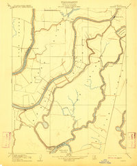
 1896 Carquinez Strait1954 Print · USGSThe industrial waterfront of the Carquinez Strait comes alive in the 1890s, where shipping channels meet the rails. Genealogists and historians can trace early bay settlements from the U.S. Arsenal at Benicia to the rail hubs of Vallejo and Martinez.
 - 1898 Map of Karquines
 1898 Karquines1898 Print · USGSThe Karquines Strait and Suisun Bay served as a bustling maritime and rail crossroads in the late nineteenth century. Researchers can trace the early layouts of Benicia, Vallejo, and Martinez, or locate vanished landmarks like Seal Bluff Landing and the U.S. Arsenal.
 - 1901 Map of Karquines
 1901 Karquines1901 Print · USGSNorthern California at the dawn of the twentieth century shows a landscape defined by the deep-water Karquines Strait and industrial rail hubs. Researchers can trace the waterfront activity of Benicia, Vallejo, and Martinez or the tidal marsh outposts at Drawbridge and Rush Landing.6 unique versions available
 - 1902 Map of Napa
 1902 Napa1902 Print · USGSThe Napa Valley and Carquinez Strait are captured at the turn of the century, showing a landscape defined by maritime military posts and early vineyards. Genealogists and historians can trace the Mare Island Navy Yard, the Insane Asylum, and rail stops at Zinfandel and Rutherford.6 unique versions available
 - 1907 Map of Woodland
 1907 Woodland1907 Print · USGSYolo County at the turn of the century reveals a landscape defined by early irrigation and the expansion of the Southern Pacific Railroad. Genealogists can trace family locations near Woodland, Madison, and the rural Union School.2 unique versions available
 - 1907 Map of Davisville
 1907 Davisville1907 Print · USGSYolo and Sacramento counties are captured here at a pivot point for river transit and rail growth. Researchers can trace early rural life via the Lisbon School, Taylor Monument Datey's Ferry, and the original footprint of Davisville.2 unique versions available
 - 1907 Map of Antioch, 1955 Print
 1907 Antioch1955 Print · USGSThe Suisun Bay and Sacramento Delta regions are captured here in the early twentieth century during a period of agricultural and industrial expansion. Local historians can trace family-named river ports like Lingos Landing and rural landmarks such as Scandia School or the settlement of Birds Landing.
 - 1908 Map of Vacaville
 1908 Vacaville1908 Print · USGSNorthern California's agricultural heartland is captured here at the start of the century, centered on the rail corridors of the Southern Pacific. Genealogists can trace early homesteads and rail stops like Elmira, Maine Prairie, and the Cement Mill.3 unique versions available
 - 1908 Map of Courtland
 1908 Courtland1908 Print · USGSThe Sacramento Delta at the dawn of the twentieth century was a landscape of fertile river islands and vital waterborne transit. Genealogists and historians can trace the early footprints of Courtland, Clarksburg, and Freeport, or locate landmarks like the Free County Ferry and Indian Mound.3 unique versions available
 - 1908 Map of Antioch
 1908 Antioch1908 Print · USGSThe convergence of the great California rivers in the early twentieth century shows a landscape of busy water landings and growing rail towns. Trace the industrial roots of Antioch or locate vanished landings like Palmetto Landing and Duttons Landing along the sloughs.5 unique versions available
 - 1910 Map of Rio Vista
 1910 Rio Vista1910 Print · USGSThe Sacramento River delta in the early twentieth century was a complex network of island farms and winding waterways. Genealogists and historians can trace old settlements like Rio Vista and Newtown, or locate the specific Blacksmith Shop in the foothills.2 unique versions available
 - 1910 Map of Jersey
 1910 Jersey1910 Print · USGSThe California Delta at the start of the century was a landscape of river-bound islands and vital steamboat landings. Genealogists and historians can trace old waterfront sites like Larsen Landing and Jersey, or the rail path of the A T and S F R R.3 unique versions available
 - 1910 Map of Isleton
 1910 Isleton1910 Print · USGSThe California Delta's intricate landscape of reclaimed islands and sloughs is captured here just after the turn of the century. You can trace early riverfront settlements like Isleton and Walnut Grove, or locate the waterfront Golden State Cannery.3 unique versions available
 - 1915 Map of Swingle
 1915 Swingle1915 Print · USGSThe rail-driven landscape around Davis is captured here during the early twentieth century, showing the critical junction of two Southern Pacific lines. Researchers can trace early settlements and rail stops like Swingle, Briggston, and Webster along the banks of Putah Creek.
 - 1915 Map of Merritt
 1915 Merritt1915 Print · USGSYolo County was a burgeoning agricultural hub in the early twentieth century, defined by its complex network of sloughs and canals. Researchers can trace the early irrigation patterns of Putah Creek and locate vanished rail sidings like Elston Spur and the settlement of Plainfield.
 - 1916 Map of Dixon
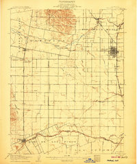
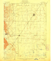
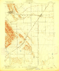
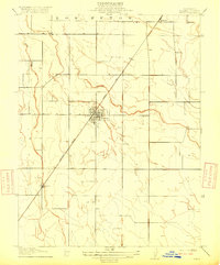 1916 Dixon1916 Print · USGSSolano County agriculture was reaching its prime in the early twentieth century, centered on the vital rail hub of Dixon. Genealogists and historians can trace the early rail stops at Batavia and Tremont along the Ogden Line.
 - 1916 Map of Mare Island
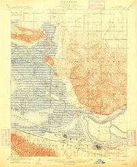
 1916 Mare Island1916 Print · USGSThe northern San Pablo Bay region comes alive in this survey, showcasing a landscape of tidal marshes and rail-driven growth during the mid-1910s. Researchers can trace the layout of the Mare Island Navy Yard, the remote rail stop at Wingo, and the rural classrooms of Fly School.4 unique versions available
 - 1916 Map of Cache Slough
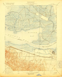
 1916 Cache Slough1916 Print · USGSThe California Delta at the turn of the century is captured in this survey of the marshlands between Solano and Yolo counties. Researchers can trace the original paths of Cache Slough and Miner Slough or locate the Oakland Antioch and Eastern rail line.
 - 1916 Map of Vorden
 1916 Vorden1916 Print · USGSThe Sacramento River delta was a bustling network of river landings and island farms in the early twentieth century. Genealogists and historians can trace the foundations of Courtland, Vorden, and Paintersville, or locate river infrastructure like Pier 13 and the ferry.
 - 1916 Map of Winters
 1916 Winters1916 Print · USGSThe agricultural plains of Yolo County are captured here in the early twentieth century as the irrigation and rail networks were maturing. Local historians can trace the original Southern Pacific rail line, the rural Union School, and the early layout of Winters along the banks of Putah Creek.
 - 1916 Map of Maine Prairie
 1916 Maine Prairie1916 Print · USGSThe Solano County delta country comes to life in the years before major land reclamation, highlighting the early electric rail era. Trace the Oakland Antioch and Eastern line as it passes Maine Prairie Sta and the landing at Maine Prairie.
 - 1916 Map of Saxon
 1916 Saxon1916 Print · USGSAgricultural lands in Solano and Yolo counties are captured here in the early twentieth century, split by a prominent railroad. Trace the path of the Oakland Antioch and Eastern through the valley and locate the small stops at Saxon and Millar.
 - 1917 Map of Wolfskill
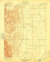 1917 Wolfskill1917 Print · USGSRail-line settlements in Solano County define this early twentieth-century landscape during the peak of the steam era. Researchers can trace the development of rural hubs along the Southern Pacific tracks, including Allendale, Hartley, and the station at Wolfskill.2 unique versions available
 - 1917 Map of Elmira
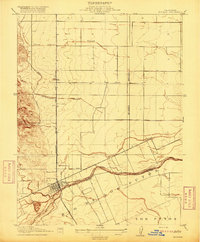
 1917 Elmira1917 Print · USGSCentral Solano County is shown at a time of significant rail and industrial development during the early twentieth century. Researchers can trace the Southern Pacific lines through Vacaville and Elmira, or locate the Cement Mill and Gas Well.
 - 1918 Map of Honker Bay
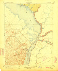
 1918 Honker Bay1918 Print · USGSThe industrial waterfront of Contra Costa and Solano counties comes alive in this survey of the Sacramento River delta. Trace the rail networks at Pittsburg and find historic riverfront stops like Birds Landing and Yolo Landing.2 unique versions available
Showing maps 1-25 of 230
Top cities of Solano County
- Vallejo historical maps
- Fairfield historical maps
- Vacaville historical maps
- Suisun City historical maps
- Benicia historical maps
- Dixon historical maps
See more
Frequently asked questions
- What are the different types of historical maps available for Solano County?
- What is the oldest map of Solano County?
- Where can I purchase historical maps of Solano County for my home or office?
- Where can I download high-res historical maps of Solano County?
- Are there historical topographic maps available for Solano County?
- Is there historical aerial imagery available for Solano County?
- Where are historical maps of Solano County sourced from?