1950s Maps of Solano County, California
Explore 47 historic maps of Solano County from the 1950s. These maps offer a rare glimpse into what life looked like during the 1950s — showing old roads, neighborhoods, homes, and landmarks that have changed or disappeared over time.
Whether you're researching your family's past, planning a metal detecting trip, or studying how Solano County's landscape evolved across the 1950s, these high-resolution maps are a powerful tool for exploring the history of this region.
- Focus on a specific era: All maps on this page are from the 1950s, giving you a focused view of this time period.
- See what’s changed: Compare century-old streets, trails, and buildings to today's modern landscape using overlays and satellite layers.
- Research with precision: Use these maps for genealogy, historical research, land use analysis, or educational projects.
- View, download, or print: Maps are fully viewable online in high resolution, and can be downloaded or printed for your own records.
Start exploring Solano County's history through authentic maps from the 1950s. This is your window into the past.
Solano County, CA maps
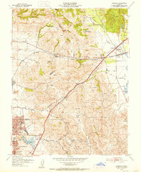
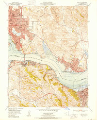
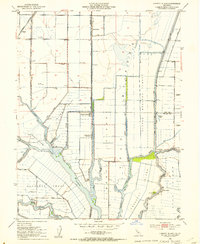
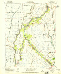
(47)- 1950 Map of Fairfield
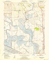
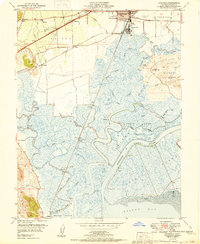 1950 Fairfield1950 Print · USGSMid-century Fairfield and Suisun City sit at the edge of a massive marshland network just before suburban expansion transformed the North Bay. Researchers can trace the era's hunting club culture and rail history at State Game Refuge, Armijo HS, and Sacramento Northern rail stops.
 - 1950 Map of Benicia, 1956 Print
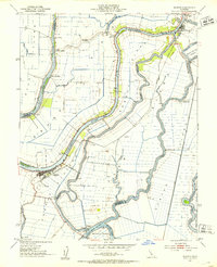
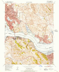 1950 Benicia1956 Print · USGSThe Carquinez Strait bustles with industrial and maritime activity in the years following the war, from the refinery at Oleum to the rail hubs of Martinez. Genealogists and historians can trace old neighborhoods like Valona, find the Carquinez Cemetery, or locate the California Maritime Academy.
 - 1951 Map of Petaluma Point
 1951 Petaluma Point1951 Print · USGSSan Pablo Bay and the Marin shoreline are captured here in the early fifties, detailing the transition from tidal marsh to inland hills. Trace the path of the Northwestern Pacific railroad past Rose or explore the historic site at China Camp.2 unique versions available
 - 1951 Map of Antioch
 1951 Antioch1951 Print · USGSThe Sacramento Delta comes alive in the early fifties as industrial growth meets a complex world of sloughs and islands. Trace family ties to Birds Landing, the Grizzly Island Ferry, or the sprawling grounds of Camp Stoneman.
 - 1951 Map of Mare Island
 1951 Mare Island1951 Print · USGSThe industrial and naval might of the East Bay is on full display in the early fifties, centering on the massive Mare Island Naval Reservation. Trace the growth of Vallejo and the waterfront towns of Rodeo and Hercules along the Southern Pacific rail line.
 - 1951 Map of Port Chicago
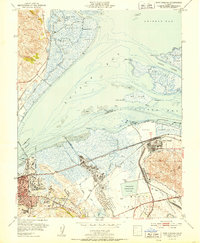 1951 Port Chicago1951 Print · USGSIn the early fifties, the industrial shoreline of Suisun Bay was defined by massive naval installations and oil refineries. Trace the rail-and-water economy through the Port Chicago Naval Reservation, the town of Clyde, and the Avon (Associated PO) refinery.2 unique versions available
 - 1951 Map of Cuttings Wharf
 1951 Cuttings Wharf1951 Print · USGSThe Napa River delta and San Pablo Bay marshes come to life in this early 1950s survey of the California waterfront. Genealogists and historians can trace the development of Cuttings Wharf and Dutton Landing, or locate the Lachman Club among the sloughs.
 - 1951 Map of Capell Valley, 1952 Print
 1951 Capell Valley1952 Print · USGSNapa County's upland canyons and ranching valleys are captured here during the early fifties, showing a rural landscape before modern development. Genealogists and historians can locate family landmarks like Munson Ranch, the Wooden Valley School, and the settlement at Moskowite.5 unique versions available
 - 1951 Map of Mt. Vaca, 1952 Print
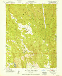
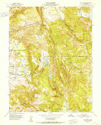
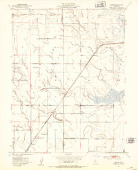
 1951 Mt. Vaca1952 Print · USGSSolano County rangelands and the steep ridges of the Vaca Mountains appear here as they were in the early fifties. Local historians and genealogists can trace family holdings like Pioneer Ranch or find the former site of the Rhine School (Abandoned) along Alamo Creek.3 unique versions available
 - 1951 Map of Sears Point, 1952 Print
 1951 Sears Point1952 Print · USGSThe northern edge of San Pablo Bay comes alive in the early fifties, showing a landscape of tidal sloughs and rail junctions. Genealogists and historians can trace the tracks of the Southern Pacific to settlements like Schellville, Wingo, and the Tule Vista School.5 unique versions available
 - 1951 Map of Cordelia, 1952 Print
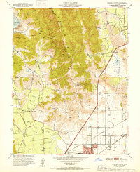
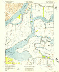
 1951 Cordelia1952 Print · USGSNorth of Vallejo in the early fifties, this area shows a landscape of developing neighborhoods and heavy industry. Genealogists and historians can locate the Permanente Foundation Hospital, the St John Mine, and the rail junction at Cordelia.9 unique versions available
 - 1951 Map of Fairfield North, 1952 Print
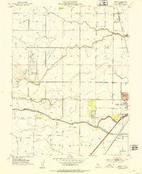
 1951 Fairfield North1952 Print · USGSNorthern Solano County in the early fifties shows a landscape of mountain ridges and valley farms. Genealogists and historians can trace old homesteads and landmarks like the Pena House, Mankas Corner, and Suisun School.7 unique versions available
 - 1951 Map of Mt. George, 1952 Print
 1951 Mt. George1952 Print · USGSThe Napa and Solano county highlands are captured here in the early fifties, a landscape defined by vital water reservoirs and rural estate development. Local historians can trace family-named landmarks like Chimiles Farm Center and Mt George Union Sch alongside the early fairways of the Green Valley Golf Club.5 unique versions available
 - 1951 Map of Mt. Vaca, 1959 Print
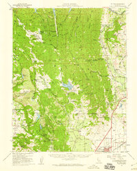 1951 Mt. Vaca1959 Print · USGSNorthern California's agricultural valleys and ridges are captured here in the early fifties. Researchers can trace rural life through landmarks like Peña House, Mankas Corner, and schools such as Gordon Valley School.2 unique versions available
 - 1952 Map of Benicia
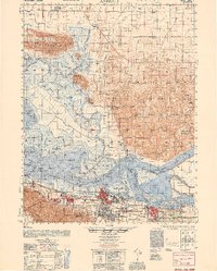
 1952 Benicia1952 Print · USGSThe Carquinez Strait corridor was a bustling industrial and maritime hub in the early fifties, bridging Solano and Contra Costa counties. Researchers can trace the waterfront rail lines of the Southern Pacific and locate landmarks like the California Maritime Academy and Nevada Dock.
 - 1952 Map of Dixon, 1953 Print
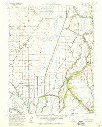
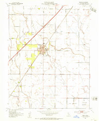 1952 Dixon1953 Print · USGSDixon and its surrounding ranchlands are captured here during a period of steady mid-century growth along the rail lines. Researchers can trace the layout of the County Fairgrounds, locate the Tremont School, and identify old rail stops like Sucro and Batavia.12 unique versions available
 - 1952 Map of Merritt, 1953 Print
 1952 Merritt1953 Print · USGSThe Yolo County plains come alive in the early 1950s, showing the early campus of the University of California College of Agriculture. Researchers can trace the legacy of the Southern Pacific through Merritt or locate mid-century landmarks like the Drive-in Theatre.6 unique versions available
 - 1952 Map of Saxon, 1953 Print
 1952 Saxon1953 Print · USGSSolano and Yolo counties are captured here in the early fifties, showing a landscape of established ranching and strategic water management. Genealogists and local historians can trace family-named lands like Bulkley Ranch and find the historic Tremont Cem near the Sacramento Northern line.5 unique versions available
 - 1952 Map of Liberty Island, 1953 Print
 1952 Liberty Island1953 Print · USGSThe California Delta's reclaimed marshlands are shown here in the early fifties, just as the region's hydraulic systems and gas exploration were maturing. Researchers can trace the levee-protected agricultural tracts of Liberty Island and find local landmarks like Liberty Farms and the Swing Bridge.3 unique versions available
 - 1952 Map of Isleton, 1953 Print
 1952 Isleton1953 Print · USGSThe Sacramento Delta is captured in the early fifties as a landscape of levees, islands, and riverfront towns. Genealogists and historians can trace Isleton, the historic town of Locke, and local landmarks like Ryer Island Sch and Howard Landing.3 unique versions available
 - 1952 Map of Dozier, 1953 Print
 1952 Dozier1953 Print · USGSThe Solano County wetlands and plains in the early fifties show a landscape of drainage cuts and rail-side settlements. Genealogists and historians can trace the Maine Prairie (Site) and stops along the Sacramento Northern like Dozier.5 unique versions available
 - 1952 Map of Davis, 1953 Print
 1952 Davis1953 Print · USGSDavis and the University of California campus are centered in this mid-century survey of the Yolo County agricultural corridor. Researchers can trace the early footprint of the College of Agriculture, the Southern Pacific rail line, and the rural site of Swingle.8 unique versions available
 - 1952 Map of Courtland, 1953 Print
 1952 Courtland1953 Print · USGSThe Sacramento Delta in the early fifties shows a landscape of engineered waterways and island farming communities. Genealogists and historians can trace the development of riverfront towns like Courtland and Locke or follow the Southern Pacific rail line.6 unique versions available
 - 1952 Map of Jersey Island, 1954 Print
 1952 Jersey Island1954 Print · USGSThe Sacramento-San Joaquin River Delta at mid-century is captured here as a sprawling network of leveed islands and tidal sloughs. Genealogists and historians can trace the early roads of Bethel Island or locate the Mayberry Slough Facility Military Reservation and the ferry crossing at Fishermans Cut.3 unique versions available
 - 1952 Map of Courtland, 1959 Print
 1952 Courtland1959 Print · USGSThe Sacramento Delta comes alive in the early fifties, showing a landscape defined by river commerce and sprawling ranch holdings. Family researchers can locate Tremont Cem, Liberty Sch, and long-established properties like Glide Ranch and Maxwell Ranch.3 unique versions available
Showing maps 1-25 of 47
Top cities of Solano County
- Vallejo historical maps
- Fairfield historical maps
- Vacaville historical maps
- Suisun City historical maps
- Benicia historical maps
- Dixon historical maps
See more
Frequently asked questions
- What are the different types of historical maps available for Solano County?
- What is the oldest map of Solano County?
- Where can I purchase historical maps of Solano County for my home or office?
- Where can I download high-res historical maps of Solano County?
- Are there historical topographic maps available for Solano County?
- Is there historical aerial imagery available for Solano County?
- Where are historical maps of Solano County sourced from?