Old Maps of Dozier, California for Academic Research
Study the evolution of Dozier with 14 high-resolution historic maps. Whether you're teaching, researching, or modeling changes in land use, these maps provide essential visual documentation of urban, environmental, and geographic change.
- Analyze long-term change: Track patterns in development, transportation, and natural features.
- Ideal for environmental or urban studies: Support academic projects with primary historical map data.
- Use in the classroom or lab: Educators and researchers rely on these maps to bring historical context to life.
These maps are a powerful tool for teaching, research, and visualizing how Dozier has changed over the decades.
Dozier, CA maps
(14)- 1908 Map of Vacaville
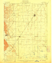 1908 Vacaville1908 Print · USGSNorthern California's agricultural heartland is captured here at the start of the century, centered on the rail corridors of the Southern Pacific. Genealogists can trace early homesteads and rail stops like Elmira, Maine Prairie, and the Cement Mill.3 unique versions available
 - 1916 Map of Maine Prairie
 1916 Maine Prairie1916 Print · USGSThe Solano County delta country comes to life in the years before major land reclamation, highlighting the early electric rail era. Trace the Oakland Antioch and Eastern line as it passes Maine Prairie Sta and the landing at Maine Prairie.
 - 1941 Map of Vacaville
 1941 Vacaville1941 Print · USGSSolano County’s fertile ranching and orchard lands are documented in the early 1940s, just before significant regional growth. Local historians can trace family-named school districts like Tremont District School and rural rail stops including Batavia and Cannon.
 - 1947 Map of Sacramento, 1948 Print
 1947 Sacramento1948 Print · USGSThe Sacramento Valley meets the high Sierra during a period of post-war expansion. Trace the historic river delta islands like Grand Island or locate early airfield footprints at McClellan Air Force Base and Mather Air Force Base.2 unique versions available
 - 1948 Map of Sacramento, 1951 Print
 1948 Sacramento1951 Print · USGSPost-war Northern California comes alive in this regional survey, capturing the era of expansion between the Central Valley and the High Sierra. Researchers can trace the rail networks of the Central California Traction and Sacramento Northern RR or locate landmarks like the State Capitol and University of California Davis.
 - 1952 Map of Dozier, 1953 Print
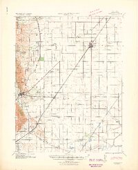
 1952 Dozier1953 Print · USGSThe Solano County wetlands and plains in the early fifties show a landscape of drainage cuts and rail-side settlements. Genealogists and historians can trace the Maine Prairie (Site) and stops along the Sacramento Northern like Dozier.5 unique versions available
 - 1953 Map of Vacaville, 1959 Print
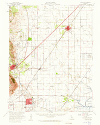 1953 Vacaville1959 Print · USGSSolano County's agricultural heartland is documented here during the mid-fifties as the local rail and military presence expanded. Genealogists and historians can trace numerous rural school sites like Grant Sch and lost rail stops such as Batavia or Dozier.
 - 1956 Map of Sacramento
 1956 Sacramento1956 Print · USGSMid-century California unfolds from the delta to the high Sierra, capturing a landscape of growing valley cities and burgeoning military airbases. Genealogists and historians can trace the rail lines and river towns from Woodland to Lodi, or explore the foothill settlements of Placerville and Jackson.2 unique versions available
 - 1957 Map of Sacramento, 1966 Print
 1957 Sacramento1966 Print · USGSIn the mid-twentieth century, the California heartland was a hub of river transport, rail lines, and military airbases. Genealogists and historians can trace the development of Gold Country towns like Angels Camp and Sonora or follow the path of the Southern Pacific RR through the growing suburbs of Sacramento.4 unique versions available
 - 1993 Map of Lodi, 1994 Print
 1993 Lodi1994 Print · USGSNorthern California's delta country and the growing Central Valley corridors are captured here in the early nineties. Genealogists and historians can trace the intricate island tracts, old railroad lines like the Sacramento Northern RR, and established local landmarks including the Lodi Memorial Cemetery and University of the Pacific.2 unique versions available
 - 2012 Map of Dozier, 2012 Print
 2012 Dozier2012 Print · USGSCovers Dozier, including Binghamton, Vale, and other nearby areas
 - 2015 Map of Dozier, 2015 Print
 2015 Dozier2015 Print · USGSCovers Dozier, including Binghamton, Vale, and other nearby areas
 - 2018 Map of Dozier, 2018 Print
 2018 Dozier2018 Print · USGSCovers Dozier, including Binghamton, Vale, and other nearby areas
 - 2022 Map of Dozier, 2022 Print
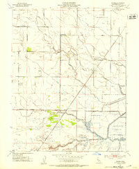
 2022 Dozier2022 Print · USGSSolano County’s agricultural heartland is documented here in the early twenty-first century, showing a landscape defined by its complex sloughs and irrigation channels. Researchers can trace the layout of rural communities like Binghamton, Dozier, and Maine Prairie alongside the historic Binghamton Cem.
End of results
Showing maps 1-14 of 14
Top cities near Dozier
- Fairfield historical maps
- Vacaville historical maps
- Suisun City historical maps
- Dixon historical maps
- Rio Vista historical maps
- Isleton historical maps
Frequently asked questions
- What are the different types of historical maps available for Dozier?
- What is the oldest map of Dozier?
- Where can I purchase historical maps of Dozier for my home or office?
- Where can I download high-res historical maps of Dozier?
- Are there historical topographic maps available for Dozier?
- Is there historical aerial imagery available for Dozier?
- Where are historical maps of Dozier sourced from?