1950s Maps of Mankas Corner, California
Explore 3 historic maps of Mankas Corner from the 1950s. These maps offer a rare glimpse into what life looked like during the 1950s — showing old roads, neighborhoods, homes, and landmarks that have changed or disappeared over time.
Whether you're researching your family's past, planning a metal detecting trip, or studying how Mankas Corner's landscape evolved across the 1950s, these high-resolution maps are a powerful tool for exploring the history of this region.
- Focus on a specific era: All maps on this page are from the 1950s, giving you a focused view of this time period.
- See what’s changed: Compare century-old streets, trails, and buildings to today's modern landscape using overlays and satellite layers.
- Research with precision: Use these maps for genealogy, historical research, land use analysis, or educational projects.
- View, download, or print: Maps are fully viewable online in high resolution, and can be downloaded or printed for your own records.
Start exploring Mankas Corner's history through authentic maps from the 1950s. This is your window into the past.
Mankas Corner, CA maps
(3)- 1951 Map of Fairfield North, 1952 Print
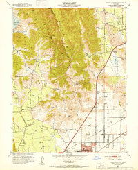 1951 Fairfield North1952 Print · USGSNorthern Solano County in the early fifties shows a landscape of mountain ridges and valley farms. Genealogists and historians can trace old homesteads and landmarks like the Pena House, Mankas Corner, and Suisun School.7 unique versions available
 - 1951 Map of Mt. Vaca, 1959 Print
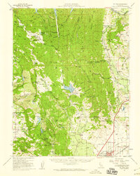 1951 Mt. Vaca1959 Print · USGSNorthern California's agricultural valleys and ridges are captured here in the early fifties. Researchers can trace rural life through landmarks like Peña House, Mankas Corner, and schools such as Gordon Valley School.2 unique versions available
 - 1958 Map of Santa Rosa, 1968 Print
 1958 Santa Rosa1968 Print · USGSThe North Bay and Wine Country are captured in the mid-twentieth century as the region balanced its agricultural roots with a growing military and recreational footprint. Researchers can trace the Northwestern Pacific RR through the Russian River valley or locate landmarks like the Petaluma Adobe Historical Monument and The Geysers Resort.3 unique versions available
End of results
Showing maps 1-3 of 3
Top cities near Mankas Corner
- Vallejo historical maps
- Fairfield historical maps
- Vacaville historical maps
- Napa historical maps
- Suisun City historical maps
- Benicia historical maps
See more
Frequently asked questions
- What are the different types of historical maps available for Mankas Corner?
- What is the oldest map of Mankas Corner?
- Where can I purchase historical maps of Mankas Corner for my home or office?
- Where can I download high-res historical maps of Mankas Corner?
- Are there historical topographic maps available for Mankas Corner?
- Is there historical aerial imagery available for Mankas Corner?
- Where are historical maps of Mankas Corner sourced from?