1950s Maps of Healdsburg, California
Explore 6 historic maps of Healdsburg from the 1950s. These maps offer a rare glimpse into what life looked like during the 1950s — showing old roads, neighborhoods, homes, and landmarks that have changed or disappeared over time.
Whether you're researching your family's past, planning a metal detecting trip, or studying how Healdsburg's landscape evolved across the 1950s, these high-resolution maps are a powerful tool for exploring the history of this region.
- Focus on a specific era: All maps on this page are from the 1950s, giving you a focused view of this time period.
- See what’s changed: Compare century-old streets, trails, and buildings to today's modern landscape using overlays and satellite layers.
- Research with precision: Use these maps for genealogy, historical research, land use analysis, or educational projects.
- View, download, or print: Maps are fully viewable online in high resolution, and can be downloaded or printed for your own records.
Start exploring Healdsburg's history through authentic maps from the 1950s. This is your window into the past.
Healdsburg, CA maps
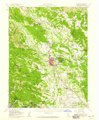
(6)- 1955 Map of Healdsburg, 1956 Print
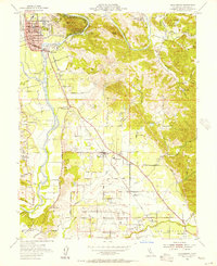 1955 Healdsburg1956 Print · USGSMid-century Sonoma County comes alive along the Russian River in this detailed survey of the valley floor and its surrounding peaks. Genealogists and local historians can locate rural landmarks like Shiloh Cem, the Grange Hall near Windsor, and the Northwestern Pacific rail line.3 unique versions available
 - 1955 Map of Jimtown, 1956 Print
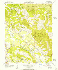 1955 Jimtown1956 Print · USGSAlexander Valley's river-bottom farms and mercury mines come to life in this mid-century survey of Sonoma's wine country. Trace local history through the Beeson Cemetery, the Alexander Valley School, and the tracks of the Northwestern Pacific.4 unique versions available
 - 1955 Map of Guerneville, 1956 Print
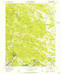 1955 Guerneville1956 Print · USGSThe Russian River resort corridor and timberlands come to life in the mid-1950s, showing the early development of Guerneville and Rio Nido. Genealogists and researchers can trace local landmarks like the Sonoma Mine, Felta Sch, and the grounds of Armstrong Redwoods State Park.4 unique versions available
 - 1955 Map of Geyserville, 1956 Print
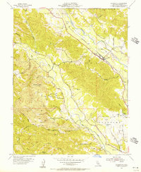 1955 Geyserville1956 Print · USGSSonoma County's wine country was already deeply shaped by its rail and river corridors in the mid-fifties. Researchers can trace the layout of Geyserville, the location of the Lytton Industrial Home, and landmarks like Olive Hill Cemetery.4 unique versions available
 - 1955 Map of Healdsburg, 1959 Print
 1955 Healdsburg1959 Print · USGSIn the mid-1950s, the Russian River valley supported a flourishing network of orchards, ranches, and small rail stops before the onset of modern development. Genealogists and local historians can trace rural roots at Shiloh Church, Beeson Cemetery, and vanished school sites like Felta Sch.2 unique versions available
 - 1958 Map of Santa Rosa, 1968 Print
 1958 Santa Rosa1968 Print · USGSThe North Bay and Wine Country are captured in the mid-twentieth century as the region balanced its agricultural roots with a growing military and recreational footprint. Researchers can trace the Northwestern Pacific RR through the Russian River valley or locate landmarks like the Petaluma Adobe Historical Monument and The Geysers Resort.3 unique versions available
End of results
Showing maps 1-6 of 6
Top cities near Healdsburg
- Santa Rosa historical maps
- Windsor historical maps
- Villa Grande historical maps
- Cloverdale historical maps
- Sebastopol historical maps
- Cobb historical maps
See more
Top neighborhoods of Healdsburg
Frequently asked questions
- What are the different types of historical maps available for Healdsburg?
- What is the oldest map of Healdsburg?
- Where can I purchase historical maps of Healdsburg for my home or office?
- Where can I download high-res historical maps of Healdsburg?
- Are there historical topographic maps available for Healdsburg?
- Is there historical aerial imagery available for Healdsburg?
- Where are historical maps of Healdsburg sourced from?