Old Maps of Shackelford, Stanislaus County for Genealogy
Trace your family roots with 18 historic maps of Shackelford. These high-res maps reveal old neighborhoods, homesites, landmarks, and streets — helping you uncover where your ancestors lived and how the area evolved over time.
- Explore historic neighborhoods: Identify where your relatives may have lived in the 1800s or 1900s.
- Compare maps over time: Trace the changes in streets, buildings, and landmarks for multi-generational research.
- Perfect for genealogy & ancestry research: Used by family historians and researchers to map out lineage and migration.
These maps are an incredible resource for exploring your personal connection to Shackelford's past.
Shackelford, Stanislaus County maps
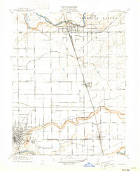
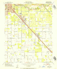
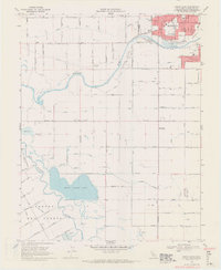
(18)- 1915 Map of Westport
 1915 Westport1915 Print · USGSCovers Shackelford, including Modesto, Ceres, and other nearby areas
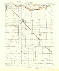
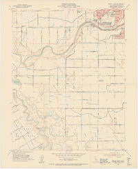
 - 1916 Map of Riverbank
 1916 Riverbank1916 Print · USGSCovers Shackelford, including Modesto, Riverbank, and other nearby areas2 unique versions available
 - 1916 Map of Ceres
 1916 Ceres1916 Print · USGSCovers Shackelford, including Modesto, Turlock, and other nearby areas2 unique versions available
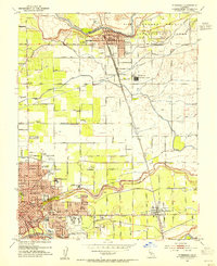
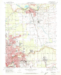
 - 1939 Map of Modesto East, 1965 Print
 1939 Modesto East1965 Print · USGSCovers Shackelford, including Modesto, Turlock, and other nearby areas
 - 1941 Map of Modesto West
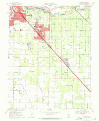
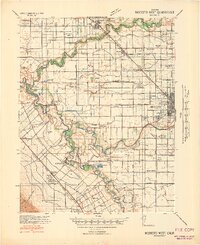 1941 Modesto West1941 Print · USGSCovers Shackelford, including Modesto, Ceres, and other nearby areas3 unique versions available
 - 1942 Map of Modesto East
 1942 Modesto East1942 Print · USGSCovers Shackelford, including Modesto, Turlock, and other nearby areas
 - 1947 Map of San Jose, 1948 Print
 1947 San Jose1948 Print · USGSCovers Shackelford, including San Jose, Stockton, and other nearby areas
 - 1953 Map of Ceres, 1954 Print
 1953 Ceres1954 Print · USGSCovers Shackelford, including Modesto, Turlock, and other nearby areas2 unique versions available
 - 1953 Map of Brush Lake, 1954 Print
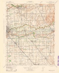
 1953 Brush Lake1954 Print · USGSCovers Shackelford, including Modesto, Ceres, and other nearby areas2 unique versions available
 - 1953 Map of Riverbank, 1954 Print
 1953 Riverbank1954 Print · USGSCovers Shackelford, including Modesto, Riverbank, and other nearby areas
 - 1956 Map of San Jose
 1956 San Jose1956 Print · USGSCovers Shackelford, including San Jose, Stockton, and other nearby areas
 - 1962 Map of San Jose
 1962 San Jose1962 Print · USGSCovers Shackelford, including San Jose, Stockton, and other nearby areas4 unique versions available
 - 1966 Map of San Jose
 1966 San Jose1966 Print · USGSCovers Shackelford, including San Jose, Stockton, and other nearby areas
 - 1969 Map of Ceres, 1971 Print
 1969 Ceres1971 Print · USGSCovers Shackelford, including Modesto, Turlock, and other nearby areas5 unique versions available
 - 1969 Map of Brush Lake, 1971 Print
 1969 Brush Lake1971 Print · USGSCovers Shackelford, including Modesto, Ceres, and other nearby areas4 unique versions available
 - 1969 Map of Riverbank, 1972 Print
 1969 Riverbank1972 Print · USGSCovers Shackelford, including Modesto, Riverbank, and other nearby areas3 unique versions available
 - 1989 Map of Stockton
 1989 Stockton1989 Print · USGSCovers Shackelford, including Stockton, Fremont, and other nearby areas2 unique versions available
 - 1994 Map of Oakdale, 1995 Print
 1994 Oakdale1995 Print · USGSCovers Shackelford, including Modesto, Turlock, and other nearby areas2 unique versions available
End of results
Showing maps 1-18 of 18
Frequently asked questions
- What are the different types of historical maps available for Shackelford?
- What is the oldest map of Shackelford?
- Where can I purchase historical maps of Shackelford for my home or office?
- Where can I download high-res historical maps of Shackelford?
- Are there historical topographic maps available for Shackelford?
- Is there historical aerial imagery available for Shackelford?
- Where are historical maps of Shackelford sourced from?