1950s Maps of Porterville, California
Explore 6 historic maps of Porterville from the 1950s. These maps offer a rare glimpse into what life looked like during the 1950s — showing old roads, neighborhoods, homes, and landmarks that have changed or disappeared over time.
Whether you're researching your family's past, planning a metal detecting trip, or studying how Porterville's landscape evolved across the 1950s, these high-resolution maps are a powerful tool for exploring the history of this region.
- Focus on a specific era: All maps on this page are from the 1950s, giving you a focused view of this time period.
- See what’s changed: Compare century-old streets, trails, and buildings to today's modern landscape using overlays and satellite layers.
- Research with precision: Use these maps for genealogy, historical research, land use analysis, or educational projects.
- View, download, or print: Maps are fully viewable online in high resolution, and can be downloaded or printed for your own records.
Start exploring Porterville's history through authentic maps from the 1950s. This is your window into the past.
Porterville, CA maps
(6)- 1951 Map of Porterville, 1952 Print
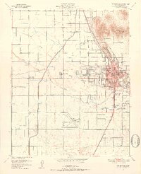 1951 Porterville1952 Print · USGSMid-century Porterville served as a bustling rail and water hub in the Tulare County valley. Genealogists and historians can trace neighborhood growth through dozens of local sites like Roche Ave Sch, St Anns Cem, and the tracks of the Southern Pacific.6 unique versions available
 - 1955 Map of Fresno
 1955 Fresno1955 Print · USGSThe Central Valley and High Sierra meet in this mid-fifties study of California’s agricultural and wilderness heart. Researchers can trace the rail-side growth of Sanger, Selma, and Reedley or locate high-altitude landmarks like Mt Whitney and Hume Lake.
 - 1956 Map of Fresno
 1956 Fresno1956 Print · USGSThe Central Valley and High Sierra meet in this mid-fifties survey of a rapidly developing California interior. Researchers can trace the rail-and-water networks of Visalia, the footprint of Tulare Lake, and the remote heights of Sequoia National Park.
 - 1956 Map of Success, 1957 Print
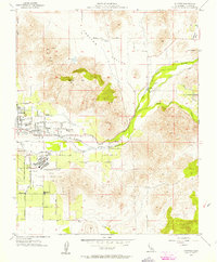 1956 Success1957 Print · USGSThe eastern Tulare County foothills come alive in the mid-fifties, showing the region before major water projects altered the riverbed. Genealogists can trace family roots near Success, Doyle Colony School, and the Porterville State Hospital.4 unique versions available
 - 1957 Map of Springville, 1961 Print
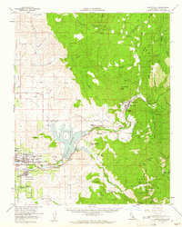 1957 Springville1961 Print · USGSTulare County's transition from valley citrus groves to Sierra Nevada foothills is captured here during the mid-fifties. Genealogists and historians can trace the foundations of Porterville and find local landmarks like the Citrus-South Tule Sch and the extensive Tule River Indian Reservation.2 unique versions available
 - 1958 Map of Fresno
 1958 Fresno1958 Print · USGSThe Central Valley and High Sierra meet in this mid-century survey of the California heartland. Researchers can trace the rail-and-road network connecting Fresno and Visalia or locate high-country landmarks like Mt Whitney and Sequoia National Park.
End of results
Showing maps 1-6 of 6
Top cities near Porterville
- Visalia historical maps
- Exeter historical maps
- Lindsay historical maps
- Farmersville historical maps
- Terra Bella historical maps
- Strathmore historical maps
See more
Top neighborhoods of Porterville
Frequently asked questions
- What are the different types of historical maps available for Porterville?
- What is the oldest map of Porterville?
- Where can I purchase historical maps of Porterville for my home or office?
- Where can I download high-res historical maps of Porterville?
- Are there historical topographic maps available for Porterville?
- Is there historical aerial imagery available for Porterville?
- Where are historical maps of Porterville sourced from?