Old Maps of Deadwood, California for Genealogy
Trace your family roots with 16 historic maps of Deadwood. These high-res maps reveal old neighborhoods, homesites, landmarks, and streets — helping you uncover where your ancestors lived and how the area evolved over time.
- Explore historic neighborhoods: Identify where your relatives may have lived in the 1800s or 1900s.
- Compare maps over time: Trace the changes in streets, buildings, and landmarks for multi-generational research.
- Perfect for genealogy & ancestry research: Used by family historians and researchers to map out lineage and migration.
These maps are an incredible resource for exploring your personal connection to Deadwood's past.
Deadwood, CA maps
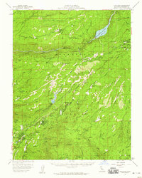
(16)- 1891 Map of Big Trees
 1891 Big Trees1891 Print · USGSThe Sierra Nevada high country and gold country are seen here in the 1890s, a period defined by the mining economy and early mountain passage. Historians can trace early routes like the Bloods Toll Road and locate sites such as Sheep Ranch, the Keltz Mine, and Swiss Ranch.
 - 1894 Map of Big Trees
 1894 Big Trees1894 Print · USGSCentral California's high Sierra region is documented here in the 1890s, where river crossings and giant sequoia groves defined the landscape. Researchers can trace old mountain routes through Abbott Ferry and Parrott Ferry or locate early mining sites like the Riverside Mine.
 - 1897 Map of Big Trees
 1897 Big Trees1897 Print · USGSThe Sierra Nevada foothills and deep river canyons of the late nineteenth century are mapped here in detail before modern development. Genealogists and historians can trace early mountain life through landmarks like Bloods Toll, the Riverside Mine, and historic crossings at Abbott Ferry.
 - 1901 Map of Big Trees
 1901 Big Trees1901 Print · USGSThe High Sierra and Gold Country meet in this turn-of-the-century look at the groves and mining camps of the Mokelumne and Stanislaus watersheds. Trace the early boundaries of the Calaveras Grove, locate the Riverside Mine, or find river crossings like Parrott Ferry.9 unique versions available
 - 1947 Map of Sacramento, 1948 Print
 1947 Sacramento1948 Print · USGSThe Sacramento Valley meets the high Sierra during a period of post-war expansion. Trace the historic river delta islands like Grand Island or locate early airfield footprints at McClellan Air Force Base and Mather Air Force Base.2 unique versions available
 - 1948 Map of Sacramento, 1951 Print
 1948 Sacramento1951 Print · USGSPost-war Northern California comes alive in this regional survey, capturing the era of expansion between the Central Valley and the High Sierra. Researchers can trace the rail networks of the Central California Traction and Sacramento Northern RR or locate landmarks like the State Capitol and University of California Davis.
 - 1956 Map of Sacramento
 1956 Sacramento1956 Print · USGSMid-century California unfolds from the delta to the high Sierra, capturing a landscape of growing valley cities and burgeoning military airbases. Genealogists and historians can trace the rail lines and river towns from Woodland to Lodi, or explore the foothill settlements of Placerville and Jackson.2 unique versions available
 - 1956 Map of Long Barn, 1959 Print
 1956 Long Barn1959 Print · USGSTuolumne County in the mid-fifties is a landscape of timber and gold, where logging spurs still wind toward the high Sierra. Genealogists and researchers can trace local family roots through mountain communities like Long Barn, Twain Harte, and Mi-Wuk Village, or locate historic workings such as the Red Cloud Mine.3 unique versions available
 - 1957 Map of Sacramento, 1966 Print
 1957 Sacramento1966 Print · USGSIn the mid-twentieth century, the California heartland was a hub of river transport, rail lines, and military airbases. Genealogists and historians can trace the development of Gold Country towns like Angels Camp and Sonora or follow the path of the Southern Pacific RR through the growing suburbs of Sacramento.4 unique versions available
 - 1979 Map of Hull Creek
 1979 Hull Creek1979 Print · USGSThe high Sierra country of Tuolumne County is captured here in the late 1970s, showcasing a landscape of remote camps and mountain meadows. Researchers can trace the legacy of local timber and ranching through the Old Railroad Grade and sites like Camp Twentyfour (Site) or Fahey Cabin.
 - 1993 Map of San Andreas, 1994 Print
 1993 San Andreas1994 Print · USGSThe Mother Lode and High Sierra foothills come alive in the 1990s, showcasing a region defined by historic gold mining and massive water projects. Genealogists and historians can locate old mining sites and rural settlements like Volcano, San Andreas, and Mokelumne Hill.
 - 2001 Map of Hull Creek, 2004 Print
 2001 Hull Creek2004 Print · USGSTuolumne County's rugged forest interior is documented here as it appeared in the early twenty-first century, centered on the high ridges of the Stanislaus National Forest. Researchers can trace the locations of old forest outposts and mountain camps, including Lee Price Camp, Faust Cabin, and Camp Clavey.
 - 2012 Map of Hull Creek, 2012 Print
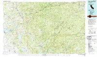
 2012 Hull Creek2012 Print · USGSCovers Deadwood, including Tuolumne County, United States, and other nearby areas
 - 2015 Map of Hull Creek, 2015 Print
 2015 Hull Creek2015 Print · USGSCovers Deadwood, including Tuolumne County, United States, and other nearby areas
 - 2018 Map of Hull Creek, 2018 Print
 2018 Hull Creek2018 Print · USGSCovers Deadwood, including Tuolumne County, United States, and other nearby areas
 - 2021 Map of Hull Creek, 2021 Print
 2021 Hull Creek2021 Print · USGSTuolumne County's high forest terrain is documented here in the early twenty-first century as a hub for mountain recreation and water resources. Trace the historical footprint of mountain life at Deadwood or locate backcountry landmarks like Milk Ranch Spring and Dodge Ridge.
End of results
Showing maps 1-16 of 16
Top cities near Deadwood
Frequently asked questions
- What are the different types of historical maps available for Deadwood?
- What is the oldest map of Deadwood?
- Where can I purchase historical maps of Deadwood for my home or office?
- Where can I download high-res historical maps of Deadwood?
- Are there historical topographic maps available for Deadwood?
- Is there historical aerial imagery available for Deadwood?
- Where are historical maps of Deadwood sourced from?