1990s Maps of Ojai, California
Explore 2 historic maps of Ojai from the 1990s. These maps offer a rare glimpse into what life looked like during the 1990s — showing old roads, neighborhoods, homes, and landmarks that have changed or disappeared over time.
Whether you're researching your family's past, planning a metal detecting trip, or studying how Ojai's landscape evolved across the 1990s, these high-resolution maps are a powerful tool for exploring the history of this region.
- Focus on a specific era: All maps on this page are from the 1990s, giving you a focused view of this time period.
- See what’s changed: Compare century-old streets, trails, and buildings to today's modern landscape using overlays and satellite layers.
- Research with precision: Use these maps for genealogy, historical research, land use analysis, or educational projects.
- View, download, or print: Maps are fully viewable online in high resolution, and can be downloaded or printed for your own records.
Start exploring Ojai's history through authentic maps from the 1990s. This is your window into the past.
Ojai, CA maps
(2)- 1995 Map of Matilija, 2000 Print
 1995 Matilija2000 Print · USGSVentura County at the edge of the Los Padres National Forest during the mid-nineties shows the interplay of old land grants and modern water management. Trace family roots and local history at the Ojai Valley Cemetery, the Matilija Hot Springs, and the Ojai Grant.
 - 1995 Map of Ojai, 2000 Print
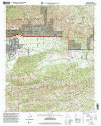 1995 Ojai2000 Print · USGSOjai and the Upper Ojai Valley are captured in the mid-nineties, showing a blend of historic land grants and rural development. Researchers can trace early property lines like the Canada Larga Verde Grant and locate landmarks such as Thacher School and Summit School.
End of results
Showing maps 1-2 of 2
Top cities near Ojai
Top neighborhoods of Ojai
Frequently asked questions
- What are the different types of historical maps available for Ojai?
- What is the oldest map of Ojai?
- Where can I purchase historical maps of Ojai for my home or office?
- Where can I download high-res historical maps of Ojai?
- Are there historical topographic maps available for Ojai?
- Is there historical aerial imagery available for Ojai?
- Where are historical maps of Ojai sourced from?