1990s Maps of Sespe, California
Explore 1 historic maps of Sespe from the 1990s. These maps offer a rare glimpse into what life looked like during the 1990s — showing old roads, neighborhoods, homes, and landmarks that have changed or disappeared over time.
Whether you're researching your family's past, planning a metal detecting trip, or studying how Sespe's landscape evolved across the 1990s, these high-resolution maps are a powerful tool for exploring the history of this region.
- Focus on a specific era: All maps on this page are from the 1990s, giving you a focused view of this time period.
- See what’s changed: Compare century-old streets, trails, and buildings to today's modern landscape using overlays and satellite layers.
- Research with precision: Use these maps for genealogy, historical research, land use analysis, or educational projects.
- View, download, or print: Maps are fully viewable online in high resolution, and can be downloaded or printed for your own records.
Start exploring Sespe's history through authentic maps from the 1990s. This is your window into the past.
Sespe, CA maps
(1)- 1995 Map of Fillmore, 2000 Print
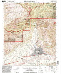 1995 Fillmore2000 Print · USGSVentura County's inland valleys and rugged highlands are captured in the mid-nineties as agricultural communities like Bardsdale and Fillmore expanded. Researchers can trace the legacy of the Southern Pacific rail line and identify family-owned landmarks like Van Tries Ranch or the Keith settlement.
End of results
Showing maps 1-1 of 1
Top cities near Sespe
- Oxnard historical maps
- Thousand Oaks historical maps
- Simi Valley historical maps
- Ventura historical maps
- Camarillo historical maps
- Moorpark historical maps
See more
Frequently asked questions
- What are the different types of historical maps available for Sespe?
- What is the oldest map of Sespe?
- Where can I purchase historical maps of Sespe for my home or office?
- Where can I download high-res historical maps of Sespe?
- Are there historical topographic maps available for Sespe?
- Is there historical aerial imagery available for Sespe?
- Where are historical maps of Sespe sourced from?