1940s Maps of Olive Hill, California
Explore 4 historic maps of Olive Hill from the 1940s. These maps offer a rare glimpse into what life looked like during the 1940s — showing old roads, neighborhoods, homes, and landmarks that have changed or disappeared over time.
Whether you're researching your family's past, planning a metal detecting trip, or studying how Olive Hill's landscape evolved across the 1940s, these high-resolution maps are a powerful tool for exploring the history of this region.
- Focus on a specific era: All maps on this page are from the 1940s, giving you a focused view of this time period.
- See what’s changed: Compare century-old streets, trails, and buildings to today's modern landscape using overlays and satellite layers.
- Research with precision: Use these maps for genealogy, historical research, land use analysis, or educational projects.
- View, download, or print: Maps are fully viewable online in high resolution, and can be downloaded or printed for your own records.
Start exploring Olive Hill's history through authentic maps from the 1940s. This is your window into the past.
Olive Hill, CA maps
(4)- 1941 Map of Bangor, 1958 Print
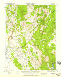 1941 Bangor1958 Print · USGSThe Butte and Yuba County foothills are captured in the early 1940s, showing a landscape of scattered mining claims and rural homesteads. Genealogists can trace family roots through several local landmarks like Upham Cem, Wyandotte Sch, and the Phoenix Mine.
 - 1944 Map of Bangor
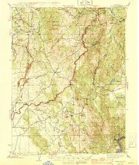 1944 Bangor1944 Print · USGSThe foothills of the Sierra Nevada are captured here during the early 1940s, showing a landscape defined by gold mining and timber production. Researchers can pinpoint long-standing landmarks such as Hansonville, the Blue Lead Mine, and several rural burial grounds like Upham Cem.2 unique versions available
 - 1947 Map of Loma Rica, 1956 Print
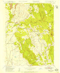 1947 Loma Rica1956 Print · USGSThe Yuba and Butte county borderlands appear in the late 1940s as a landscape of foothill ranching and legacy mining. Trace family roots at Honcut Cem or find old mining sites like the Sweet Vengeance Mine and Smethurst Mine (Abandoned).3 unique versions available
 - 1949 Map of Loma Rica
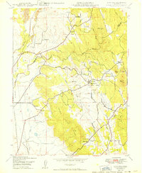 1949 Loma Rica1949 Print · USGSThe foothills of Yuba and Butte counties come alive in the late 1940s, showing a landscape shaped by irrigation and gold-era mining. Genealogists can locate family landmarks like Honcut Cem, Kings Sch, and the curious Stone House settlement.
End of results
Showing maps 1-4 of 4
Top cities near Olive Hill
- Yuba City historical maps
- Linda historical maps
- Olivehurst historical maps
- Oroville historical maps
- Marysville historical maps
- Live Oak historical maps
See more
Frequently asked questions
- What are the different types of historical maps available for Olive Hill?
- What is the oldest map of Olive Hill?
- Where can I purchase historical maps of Olive Hill for my home or office?
- Where can I download high-res historical maps of Olive Hill?
- Are there historical topographic maps available for Olive Hill?
- Is there historical aerial imagery available for Olive Hill?
- Where are historical maps of Olive Hill sourced from?