Old Maps of Wheatland, California for Academic Research
Study the evolution of Wheatland with 33 high-resolution historic maps. Whether you're teaching, researching, or modeling changes in land use, these maps provide essential visual documentation of urban, environmental, and geographic change.
- Analyze long-term change: Track patterns in development, transportation, and natural features.
- Ideal for environmental or urban studies: Support academic projects with primary historical map data.
- Use in the classroom or lab: Educators and researchers rely on these maps to bring historical context to life.
These maps are a powerful tool for teaching, research, and visualizing how Wheatland has changed over the decades.
Wheatland, CA maps
(33)- 1888 Map of Smartsville
 1888 Smartsville1888 Print · USGSGold Country was in its industrial prime during the late eighteen-hundreds, with deep-shaft mines and hydraulic camps dotting the Sierra foothills. Researchers can trace early family holdings and mining claims through landmarks like French Corral, the North Star Mine, and the historic settlement of Timbuctoo.
 - 1891 Map of Sacramento
 1891 Sacramento1891 Print · USGSNorthern California foothills and the valley plains emerge in the late nineteenth century as the rail-and-road network expands. Trace early family landmarks and river crossings like Mormon Island, Whitney Ranch, and the historic Rattlesnake Bridge.
 - 1891 Map of Smartsville
 1891 Smartsville1891 Print · USGSGold Country in the late nineteenth century was a landscape of deep mines and timber rails. This survey allows researchers to trace the industrial footprint of the Idaho and North Star Mine alongside vanished camps like Condemned Bar and French Corral.
 - 1892 Map of Sacramento
 1892 Sacramento1892 Print · USGSThe rail-and-river economy of Northern California is on full display in the 1890s as the Central Pacific Railroad links the valley to the foothills. Genealogists and historians can trace early settlements like Mormon Island, Salmon Falls, and the Whitney's Ranch before modern development changed the landscape.5 unique versions available
 - 1892 Map of Smartsville
 1892 Smartsville1892 Print · USGSThe gold-bearing ridges of the Sierra foothills are captured here in the late nineteenth century, showing the height of the hard-rock mining boom. Researchers can trace the narrow-gauge rail lines and locate famous claims including the Empire Mine, Idaho Mine, and the Sulphuret Works.
 - 1893 Map of Sacramento, 1900 Print
 1893 Sacramento1900 Print · USGSThe Sacramento Valley and Sierra foothills come alive in this late nineteenth-century survey during the height of the railroad era. Researchers can trace the early layout of Roseville, locate family landmarks like Whitney's Ranch, or follow the Placerville Road through the gold country.
 - 1894 Map of Smartsville
 1894 Smartsville1894 Print · USGSIn the mid-1880s, the Sierra foothills around Nevada City and Grass Valley were a hive of mining and ranching activity. Genealogists and historians can trace old homesteads like Lanes Ranch, follow the Nevada Co Narrow Gauge RR, and locate forgotten camps like Rough & Ready.
 - 1895 Map of Smartsville
 1895 Smartsville1895 Print · USGSThe Northern Mother Lode thrives during the peak of industrial quartz mining in the late nineteenth century. Researchers can trace the complex rail and mine networks of Nevada City and Grass Valley, alongside historic outposts like Smartsville and Rough & Ready.6 unique versions available
 - 1910 Map of Sheridan
 1910 Sheridan1910 Print · USGSNear the Placer and Sutter county line in the early 1900s, this area was a landscape of historic land grants and vital rail links. Genealogists and historians can trace the tracks of the S. P. R. R. (Marysville Line) past Sheridan and locate the rural Fairview School.2 unique versions available
 - 1910 Map of Wheatland
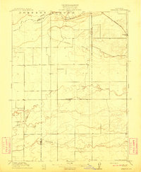
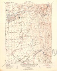
 1910 Wheatland1910 Print · USGSThe Wheatland area at the dawn of the twentieth century was a landscape of expansive ranching lands and developing rail corridors. Researchers can trace the massive Johnson Rancho boundary, locate the Eagle School, and find the early settlement of Horstville.2 unique versions available
 - 1942 Map of Markham Ravine
 1942 Markham Ravine1942 Print · USGSWestern Placer County was a landscape of busy rail lines and rural schoolhouses in the early 1940s. Genealogists and historians can trace old homesteads near Sheridan, locate the Clay Quarry at Lincoln, or find former community centers like Central Sch.
 - 1947 Map of Sacramento, 1948 Print
 1947 Sacramento1948 Print · USGSThe Sacramento Valley meets the high Sierra during a period of post-war expansion. Trace the historic river delta islands like Grand Island or locate early airfield footprints at McClellan Air Force Base and Mather Air Force Base.2 unique versions available
 - 1947 Map of Wheatland, 1958 Print
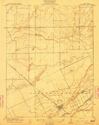
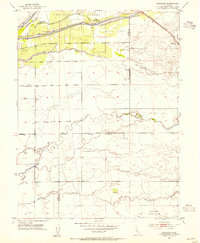
 1947 Wheatland1958 Print · USGSWheatland and the surrounding ranchlands are shown shortly after the war, when the railroad and river systems dictated local commerce. Researchers can trace family-named sites like Johnson Ranch and Horstville or the early boundaries of the Camp Beale Military Reservation.4 unique versions available
 - 1948 Map of Sacramento, 1951 Print
 1948 Sacramento1951 Print · USGSPost-war Northern California comes alive in this regional survey, capturing the era of expansion between the Central Valley and the High Sierra. Researchers can trace the rail networks of the Central California Traction and Sacramento Northern RR or locate landmarks like the State Capitol and University of California Davis.
 - 1949 Map of Wheatland
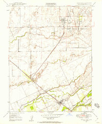
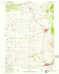
 1949 Wheatland1949 Print · USGSWheatland and the surrounding agricultural landscape are shown here in the late 1940s as the regional economy balanced ranching with military development. Researchers can trace family-named lands like Boardman Ranch and Durst Ranch, or explore the wartime footprint of the Camp Beale Military Reservation.
 - 1949 Map of Wheatland, 1953 Print
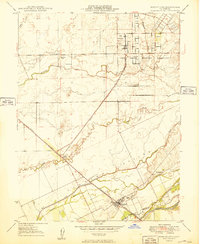
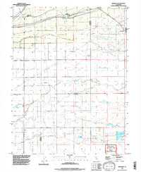
 1949 Wheatland1953 Print · USGSYuba and Nevada counties appear here during the postwar transition of the late 1940s, showing a landscape defined by massive gold dredging and military expansion. Genealogists and historians can trace the foundations of Camp Beale Military Reservation or locate early mining sites like Timbuctoo and the Pennsylvania Mine.3 unique versions available
 - 1953 Map of Sheridan, 1954 Print
 1953 Sheridan1954 Print · USGSSheridan and the surrounding ranchlands are captured here in the early 1950s, showing the intersection of the Central Valley’s water and rail networks. Researchers can trace historic land boundaries like the Johnson Grant Rancho and old infrastructure along the Southern Pacific railroad.4 unique versions available
 - 1953 Map of Lincoln, 1959 Print
 1953 Lincoln1959 Print · USGSMid-century Placer County is captured here during a period of agricultural stability and industrial growth. Researchers can trace family ranching legacies at WF Fiddyment Ranch or explore the clay industry near Clayton and Lincoln.2 unique versions available
 - 1956 Map of Sacramento
 1956 Sacramento1956 Print · USGSMid-century California unfolds from the delta to the high Sierra, capturing a landscape of growing valley cities and burgeoning military airbases. Genealogists and historians can trace the rail lines and river towns from Woodland to Lodi, or explore the foothill settlements of Placerville and Jackson.2 unique versions available
 - 1957 Map of Sacramento, 1966 Print
 1957 Sacramento1966 Print · USGSIn the mid-twentieth century, the California heartland was a hub of river transport, rail lines, and military airbases. Genealogists and historians can trace the development of Gold Country towns like Angels Camp and Sonora or follow the path of the Southern Pacific RR through the growing suburbs of Sacramento.4 unique versions available
 - 1958 Map of Chico, 1962 Print
 1958 Chico1962 Print · USGSMid-century Northern California comes to life across the Central Valley and high Sierras as the postwar economy transformed the landscape. Trace the rail lines of the Southern Pacific RR, locate family roots near Chico Cem, or explore the early layout of Paradise and Beale Air Force Base.4 unique versions available
 - 1960 Map of Chico
 1960 Chico1960 Print · USGSThe Northern California high country and Sacramento Valley meet in this 1960s-era landscape of mining towns and river settlements. Trace the rail-and-water economy of the gold country through the Empire Mine, Beale Air Force Base, and the Western Pacific Railroad.
 - 1992 Map of Sheridan, 1997 Print
 1992 Sheridan1997 Print · USGSSheridan and the surrounding Placer County ranchlands are captured here in the early nineties, revealing a landscape of managed water and historic land grants. Researchers can trace irrigation networks along Yankee Slough and the borders of the Johnson Rancho.
 - 1993 Map of Yuba City, 1994 Print
 1993 Yuba City1994 Print · USGSThe Sacramento Valley and Sierra Nevada foothills meet in the 1990s, where agricultural bypasses and river networks surround the iconic Sutter Buttes. Researchers can trace the rail corridors of the Southern Pacific and Western Pacific through hubs like Marysville and Gridley.
 - 1994 Map of Sacramento
 1994 Sacramento1994 Print · USGSThe Sacramento valley was a landscape of massive flood control and military aviation during the mid-nineties. Researchers can trace the complex network of the Yolo Bypass and the Sacramento River alongside McClellan Air Force Base and Zamora.2 unique versions available
Showing maps 1-25 of 33
Top cities near Wheatland
- Roseville historical maps
- Yuba City historical maps
- Rocklin historical maps
- Lincoln historical maps
- Linda historical maps
- Olivehurst historical maps
See more
Frequently asked questions
- What are the different types of historical maps available for Wheatland?
- What is the oldest map of Wheatland?
- Where can I purchase historical maps of Wheatland for my home or office?
- Where can I download high-res historical maps of Wheatland?
- Are there historical topographic maps available for Wheatland?
- Is there historical aerial imagery available for Wheatland?
- Where are historical maps of Wheatland sourced from?