1950s Maps of Brighton, Colorado
Explore 11 historic maps of Brighton from the 1950s. These maps offer a rare glimpse into what life looked like during the 1950s — showing old roads, neighborhoods, homes, and landmarks that have changed or disappeared over time.
Whether you're researching your family's past, planning a metal detecting trip, or studying how Brighton's landscape evolved across the 1950s, these high-resolution maps are a powerful tool for exploring the history of this region.
- Focus on a specific era: All maps on this page are from the 1950s, giving you a focused view of this time period.
- See what’s changed: Compare century-old streets, trails, and buildings to today's modern landscape using overlays and satellite layers.
- Research with precision: Use these maps for genealogy, historical research, land use analysis, or educational projects.
- View, download, or print: Maps are fully viewable online in high resolution, and can be downloaded or printed for your own records.
Start exploring Brighton's history through authentic maps from the 1950s. This is your window into the past.
Brighton, CO maps
(11)- 1950 Map of Fort Lupton
 1950 Fort Lupton1950 Print · USGSFort Lupton and the South Platte River valley are captured in detail during the post-war era, showing a landscape shaped by rail and irrigation. Genealogists can locate family landmarks like Hillside Cemetery, Porter Sch, and the small settlement of Wattenberg.2 unique versions available
 - 1951 Map of Hudson
 1951 Hudson1951 Print · USGSAgricultural growth and rail transport define Hudson and Tonville in the early fifties. Genealogists and historians can trace local landmarks like Mountain View Cem, Henry Lake Reservoir, and the Burlington Ditch.2 unique versions available
 - 1953 Map of Denver, 1964 Print
 1953 Denver1964 Print · USGSDenver and the Colorado Front Range are captured here during a decade of post-war growth and military expansion. Researchers can trace the sprawling rail lines of the Union Pacific, locate the State Capitol, and explore historic mountain mining hubs like Central City.6 unique versions available
 - 1954 Map of Greeley, 1966 Print
 1954 Greeley1966 Print · USGSNorthern Colorado transitions from high-alpine peaks to the irrigated South Platte valley during this mid-century period of growth. Genealogists and historians can trace rail-connected hubs like Greeley and Longmont alongside landmarks like Horsetooth Reservoir and Estes Park.3 unique versions available
 - 1957 Map of Denver
 1957 Denver1957 Print · USGSDenver and the Colorado Front Range are seen here during a mid-century period of intense military and urban expansion. Trace the footprints of the Rocky Mountain Arsenal, the early United States Air Force Academy, and the Lowry AF Base.
 - 1957 Map of Greeley
 1957 Greeley1957 Print · USGSNorthern Colorado in the mid-fifties is captured here as the agricultural plains of Weld County meet the high peaks of the Front Range. Genealogists and historians can trace rail-linked towns like Keenesburg and Roggen or locate early water features such as Boyd Lake and Fossil Creek Reservoir.
 - 1957 Map of Brighton, 1958 Print
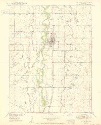
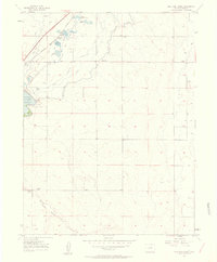
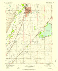 1957 Brighton1958 Print · USGSMid-century Adams County is captured here as a thriving agricultural and rail corridor along the South Platte River. Genealogists and local historians can trace rural landmarks from St Augustines Sch and the Black Cem to the early siding at Hazeltine Siding.2 unique versions available
 - 1957 Map of Eastlake, 1958 Print
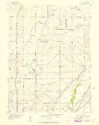 1957 Eastlake1958 Print · USGSAdams County’s farming and irrigation heartland is frozen in time in the late fifties, just as the metropolitan area began its northward shift. Researchers can trace historic water rights and small-town roots through landmarks like Eastlake, the Wesley Cem, and the Union Pacific rail siding at Hazeltine.2 unique versions available
 - 1957 Map of Mile High Lakes, 1958 Print
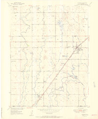
 1957 Mile High Lakes1958 Print · USGSAdams County ranching and irrigation systems are frozen in time during the late fifties. You can trace the railroad corridor through Klink, locate the Green Valley Grange Hall, and explore the networks around Barr Lake and Patton Ranch.2 unique versions available
 - 1958 Map of Greeley
 1958 Greeley1958 Print · USGSNorthern Colorado and the high peaks of the Front Range appear here in the mid-fifties as the region's agricultural and rail networks were fully established. Genealogists can locate family homes near Virginia Dale, Waverly, or Kuner, and trace the path of the Union Pacific Railroad through Greeley.
 - 1958 Map of Denver
 1958 Denver1958 Print · USGSDenver and the Colorado Front Range are captured here during the mid-century suburban boom. Trace the footprints of military installations like Buckley Air Force Base alongside the established rail networks of the Colorado & Southern Ry.
End of results
Showing maps 1-11 of 11
Top cities near Brighton
- Denver historical maps
- Aurora historical maps
- Thornton historical maps
- Westminster historical maps
- Longmont historical maps
- Commerce City historical maps
See more
Frequently asked questions
- What are the different types of historical maps available for Brighton?
- What is the oldest map of Brighton?
- Where can I purchase historical maps of Brighton for my home or office?
- Where can I download high-res historical maps of Brighton?
- Are there historical topographic maps available for Brighton?
- Is there historical aerial imagery available for Brighton?
- Where are historical maps of Brighton sourced from?