1980s Maps of Edith, Colorado
Explore 2 historic maps of Edith from the 1980s. These maps offer a rare glimpse into what life looked like during the 1980s — showing old roads, neighborhoods, homes, and landmarks that have changed or disappeared over time.
Whether you're researching your family's past, planning a metal detecting trip, or studying how Edith's landscape evolved across the 1980s, these high-resolution maps are a powerful tool for exploring the history of this region.
- Focus on a specific era: All maps on this page are from the 1980s, giving you a focused view of this time period.
- See what’s changed: Compare century-old streets, trails, and buildings to today's modern landscape using overlays and satellite layers.
- Research with precision: Use these maps for genealogy, historical research, land use analysis, or educational projects.
- View, download, or print: Maps are fully viewable online in high resolution, and can be downloaded or printed for your own records.
Start exploring Edith's history through authentic maps from the 1980s. This is your window into the past.
Edith, CO maps
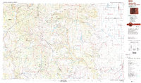
(2)- 1984 Map of Edith
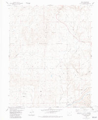 1984 Edith1984 Print · USGSThe Colorado-New Mexico borderlands come into focus in the mid-1980s, centered on the Navajo River and the high country of the San Juan National Forest. Genealogists and historians can trace an Old Railroad Grade near Edith and locate early water works like the Shahan Ditch.2 unique versions available
 - 1985 Map of Antonito
 1985 Antonito1985 Print · USGSThe Colorado and New Mexico borderlands come into focus during the mid-eighties as the high peaks of the San Juans meet the San Luis Valley. Trace the winding Cumbres and Toltec Scenic Railroad or locate historical mining sites like the Black Diamond Mine and Summitville.2 unique versions available
End of results
Showing maps 1-2 of 2
Frequently asked questions
- What are the different types of historical maps available for Edith?
- What is the oldest map of Edith?
- Where can I purchase historical maps of Edith for my home or office?
- Where can I download high-res historical maps of Edith?
- Are there historical topographic maps available for Edith?
- Is there historical aerial imagery available for Edith?
- Where are historical maps of Edith sourced from?