1900s (20th Century) Maps of Alpine, Colorado
Explore 9 historic maps of Alpine from the 1900s (20th Century). These maps offer a rare glimpse into what life looked like during the 1900s — showing old roads, neighborhoods, homes, and landmarks that have changed or disappeared over time.
Whether you're researching your family's past, planning a metal detecting trip, or studying how Alpine's landscape evolved across the 1900s, these high-resolution maps are a powerful tool for exploring the history of this region.
- Focus on a specific era: All maps on this page are from the 1900s, giving you a focused view of this time period.
- See what’s changed: Compare century-old streets, trails, and buildings to today's modern landscape using overlays and satellite layers.
- Research with precision: Use these maps for genealogy, historical research, land use analysis, or educational projects.
- View, download, or print: Maps are fully viewable online in high resolution, and can be downloaded or printed for your own records.
Start exploring Alpine's history through authentic maps from the 1900s. This is your window into the past.
Alpine, CO maps
(9)- 1940 Map of Garfield, 1954 Print
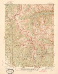
 1940 Garfield1954 Print · USGSThe high Sawatch Range is seen here at the peak of its industrial mining era, straddling the Continental Divide. Genealogists and historians can trace defunct mountain rail routes and remote settlements like St Elmo, Hancock, and the historic Old Alpine Tunnel.6 unique versions available
 - 1945 Map of Garfield
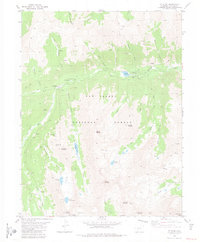
 1945 Garfield1945 Print · USGSThe high Sawatch Range and its historic mining districts appear here in the mid-1940s, just as many remote camps were reaching a quiet maturity. Genealogists and historians can trace the steep paths to St Elmo, the OLD ALPINE TUNNEL, and active sites like the GARFIELD MINE.2 unique versions available
 - 1956 Map of Montrose, 1963 Print
 1956 Montrose1963 Print · USGSThe Colorado western slope in the late fifties and early sixties shows a landscape defined by the Denver & Rio Grande Western RR and the Gunnison River. Trace the development of Blue Mesa Reservoir or locate high-country sites like the Bachelor Mine.3 unique versions available
 - 1959 Map of Montrose
 1959 Montrose1959 Print · USGSWestern Colorado in the late fifties is defined by the high peaks and river valleys of the Southern Rockies. Genealogists and historians can trace the paths of the Denver & Rio Grande Western RR or locate mountain settlements like Crawford, Lazear, and Doyleville.
 - 1960 Map of Montrose
 1960 Montrose1960 Print · USGSThe Colorado high country in the mid-fifties is captured here during a period of steady ranching and persistent mining. Researchers can trace the path of the Denver & Rio Grande Western RR or locate small settlements like Somerset, Maher, and Sargent.2 unique versions available
 - 1968 Map of Montrose
 1968 Montrose1968 Print · USGSThe Western Slope and Continental Divide meet in the late sixties, showing the vital river valleys and high-mountain mining districts. Trace the historic route of the Denver and Rio Grande Western RR or locate small settlements like Sargents and Powderhorn.
 - 1982 Map of Saint Elmo, 1983 Print
 1982 Saint Elmo1983 Print · USGSChaffee County mining districts are frozen in time during the early eighties, showing the rugged network of camps and claims. Researchers can trace the layout of St Elmo and Hancock while locating historic workings like the Mary Murphy Mine.2 unique versions available
 - 1984 Map of Gunnison
 1984 Gunnison1984 Print · USGSHigh mountain passes and historic mining districts define this mid-eighties record of the central Colorado Rockies. Genealogists and historians can trace the foundations of Gunnison and Crested Butte or locate remote sites like St Elmo, Tincup, and Hancock.2 unique versions available
 - 1994 Map of Saint Elmo, 1998 Print
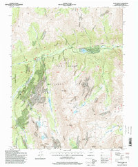 1994 Saint Elmo1998 Print · USGSThe mining camps of the Sawatch Range are documented here in the mid-nineties, showing the high-country landscape of the San Isabel National Forest. Genealogists and historians can trace the foundations of Saint Elmo, Romley, and Hancock alongside numerous mountain mines.
End of results
Showing maps 1-9 of 9
Top cities near Alpine
- Buena Vista historical maps
- Poncha Springs historical maps
- Nathrop historical maps
- Pitkin historical maps
Frequently asked questions
- What are the different types of historical maps available for Alpine?
- What is the oldest map of Alpine?
- Where can I purchase historical maps of Alpine for my home or office?
- Where can I download high-res historical maps of Alpine?
- Are there historical topographic maps available for Alpine?
- Is there historical aerial imagery available for Alpine?
- Where are historical maps of Alpine sourced from?