1980s Maps of Johnson Village, Colorado
Explore 2 historic maps of Johnson Village from the 1980s. These maps offer a rare glimpse into what life looked like during the 1980s — showing old roads, neighborhoods, homes, and landmarks that have changed or disappeared over time.
Whether you're researching your family's past, planning a metal detecting trip, or studying how Johnson Village's landscape evolved across the 1980s, these high-resolution maps are a powerful tool for exploring the history of this region.
- Focus on a specific era: All maps on this page are from the 1980s, giving you a focused view of this time period.
- See what’s changed: Compare century-old streets, trails, and buildings to today's modern landscape using overlays and satellite layers.
- Research with precision: Use these maps for genealogy, historical research, land use analysis, or educational projects.
- View, download, or print: Maps are fully viewable online in high resolution, and can be downloaded or printed for your own records.
Start exploring Johnson Village's history through authentic maps from the 1980s. This is your window into the past.
Johnson Village, CO maps
(2)- 1983 Map of Buena Vista East
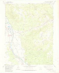 1983 Buena Vista East1983 Print · USGSUpper Arkansas Valley life in the early eighties is centered around the river and rail lines between Buena Vista and Nathrop. Researchers can trace industrial and civic history at the State Reformatory, the Nellie Bly Mine, and the Old Railroad Grade.2 unique versions available
 - 1984 Map of Gunnison
 1984 Gunnison1984 Print · USGSHigh mountain passes and historic mining districts define this mid-eighties record of the central Colorado Rockies. Genealogists and historians can trace the foundations of Gunnison and Crested Butte or locate remote sites like St Elmo, Tincup, and Hancock.2 unique versions available
End of results
Showing maps 1-2 of 2
Top cities near Johnson Village
Frequently asked questions
- What are the different types of historical maps available for Johnson Village?
- What is the oldest map of Johnson Village?
- Where can I purchase historical maps of Johnson Village for my home or office?
- Where can I download high-res historical maps of Johnson Village?
- Are there historical topographic maps available for Johnson Village?
- Is there historical aerial imagery available for Johnson Village?
- Where are historical maps of Johnson Village sourced from?