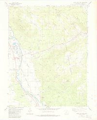
1983 Map of Buena Vista East
USGS Topo · Published 1983About this map
The Arkansas River corridor serves as the primary artery for settlement and transport in this 1983 survey of Chaffee County. Communities like Buena Vista and Johnson Village are positioned along the riverbank, while the Denver and Rio Grande Western railroad tracks parallel the water, illustrating the historical reliance on this natural valley for mountain transit. To the east, the San Isabel National Forest rises into the high country of Triad Ridge and Bald Mountain, where the land is marked by mining history. Features such as the Nellie Bly Mine and Triad Mine are tucked into the drainages of Trout Creek and Chinaman Gulch. The map also documents the State Reformatory complex and remnants of earlier transportation routes, including an Old Railroad Grade winding through Shields Gulch.
Find a feature on this map
39 named features on this map. Tap any name to fly to it.
Don’t see what you’re looking for? This feature index may not catch every label — zoom into the map to look around manually.
Map Details
Editions of this 1983 Buena Vista East Map
2 editions found
Other maps of this area

1954 · Pueblo
USGS Topo · 1:250,000

1955 · Buena Vista
USGS Topo · 1:62,500

1956 · Antero Reservoir
USGS Topo · 1:24,000

1956 · Cameron Mountain
USGS Topo · 1:62,500

1956 · Poncha Springs
USGS Topo · 1:62,500

1956 · Montrose
USGS Topo · 1:250,000

1957 · Pueblo
USGS Topo · 1:250,000

1958 · Pueblo
USGS Topo · 1:250,000

1959 · Montrose
USGS Topo · 1:250,000

1959 · Antero Reservoir
USGS Topo · 1:62,500