1960s Maps of Blanca, Colorado
Explore 2 historic maps of Blanca from the 1960s. These maps offer a rare glimpse into what life looked like during the 1960s — showing old roads, neighborhoods, homes, and landmarks that have changed or disappeared over time.
Whether you're researching your family's past, planning a metal detecting trip, or studying how Blanca's landscape evolved across the 1960s, these high-resolution maps are a powerful tool for exploring the history of this region.
- Focus on a specific era: All maps on this page are from the 1960s, giving you a focused view of this time period.
- See what’s changed: Compare century-old streets, trails, and buildings to today's modern landscape using overlays and satellite layers.
- Research with precision: Use these maps for genealogy, historical research, land use analysis, or educational projects.
- View, download, or print: Maps are fully viewable online in high resolution, and can be downloaded or printed for your own records.
Start exploring Blanca's history through authentic maps from the 1960s. This is your window into the past.
Blanca, CO maps
(2)- 1965 Map of Blanca, 1968 Print
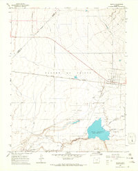 1965 Blanca1968 Print · USGSThe San Luis Valley landscape comes into focus during the mid-sixties, centered on the railroad town of Blanca. Researchers can trace irrigation patterns and early transport hubs like the Denver and Rio Grande Western rail line and the Blanca Municipal Airport.3 unique versions available
 - 1967 Map of Fort Garland, 1971 Print
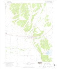 1967 Fort Garland1971 Print · USGSThe San Luis Valley meets the Sangre de Cristo foothills in the late sixties, showing a landscape defined by ranching and rail. Trace historic local heritage through the Old Fort Garland Military Reservation and family sites like MacMullan Cem and Myer Cem.3 unique versions available
End of results
Showing maps 1-2 of 2
Top cities near Blanca
Frequently asked questions
- What are the different types of historical maps available for Blanca?
- What is the oldest map of Blanca?
- Where can I purchase historical maps of Blanca for my home or office?
- Where can I download high-res historical maps of Blanca?
- Are there historical topographic maps available for Blanca?
- Is there historical aerial imagery available for Blanca?
- Where are historical maps of Blanca sourced from?