1950s Maps of Grand Mesa, Colorado
Explore 3 historic maps of Grand Mesa from the 1950s. These maps offer a rare glimpse into what life looked like during the 1950s — showing old roads, neighborhoods, homes, and landmarks that have changed or disappeared over time.
Whether you're researching your family's past, planning a metal detecting trip, or studying how Grand Mesa's landscape evolved across the 1950s, these high-resolution maps are a powerful tool for exploring the history of this region.
- Focus on a specific era: All maps on this page are from the 1950s, giving you a focused view of this time period.
- See what’s changed: Compare century-old streets, trails, and buildings to today's modern landscape using overlays and satellite layers.
- Research with precision: Use these maps for genealogy, historical research, land use analysis, or educational projects.
- View, download, or print: Maps are fully viewable online in high resolution, and can be downloaded or printed for your own records.
Start exploring Grand Mesa's history through authentic maps from the 1950s. This is your window into the past.
Grand Mesa, CO maps
(3)- 1955 Map of Grand Mesa, 1957 Print
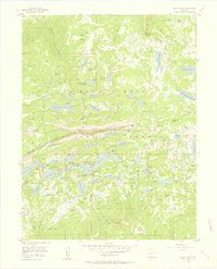 1955 Grand Mesa1957 Print · USGSMesa County and Delta County high country in the mid-fifties was a landscape of high-altitude reservoirs and foot trails. Researchers can trace the development of mountain retreats at Grand Mesa Christian Association or locate the Ward Lake Ranger Sta and Columbine Chapel.5 unique versions available
 - 1957 Map of Leadville, 1978 Print
 1957 Leadville1978 Print · USGSHigh-country mining and rail transport define the central Colorado Rockies during the mid-to-late twentieth century. Researchers can trace the industrial footprints of Gilman and Climax, find small rail stops like Malta, and follow the Denver and Rio Grande Western RR.2 unique versions available
 - 1959 Map of Leadville
 1959 Leadville1959 Print · USGSThe Colorado high country in the late fifties is a landscape of mining history and military training, from the streets of Leadville to the Camp Hale grounds. Genealogists and historians can trace the Denver and Rio Grande Western RR alongside now-deserted sites like Ashcroft and Independence.
End of results
Showing maps 1-3 of 3
Top cities near Grand Mesa
- Orchard City historical maps
- Cedaredge historical maps
- De Beque historical maps
- Collbran historical maps
Frequently asked questions
- What are the different types of historical maps available for Grand Mesa?
- What is the oldest map of Grand Mesa?
- Where can I purchase historical maps of Grand Mesa for my home or office?
- Where can I download high-res historical maps of Grand Mesa?
- Are there historical topographic maps available for Grand Mesa?
- Is there historical aerial imagery available for Grand Mesa?
- Where are historical maps of Grand Mesa sourced from?