Old Maps of Grand Mesa, Colorado for Genealogy
Trace your family roots with 12 historic maps of Grand Mesa. These high-res maps reveal old neighborhoods, homesites, landmarks, and streets — helping you uncover where your ancestors lived and how the area evolved over time.
- Explore historic neighborhoods: Identify where your relatives may have lived in the 1800s or 1900s.
- Compare maps over time: Trace the changes in streets, buildings, and landmarks for multi-generational research.
- Perfect for genealogy & ancestry research: Used by family historians and researchers to map out lineage and migration.
These maps are an incredible resource for exploring your personal connection to Grand Mesa's past.
Grand Mesa, CO maps
(12)- 1955 Map of Grand Mesa, 1957 Print
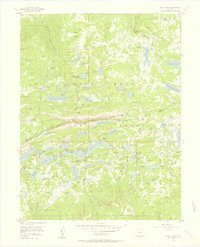 1955 Grand Mesa1957 Print · USGSMesa County and Delta County high country in the mid-fifties was a landscape of high-altitude reservoirs and foot trails. Researchers can trace the development of mountain retreats at Grand Mesa Christian Association or locate the Ward Lake Ranger Sta and Columbine Chapel.5 unique versions available
 - 1957 Map of Leadville, 1978 Print
 1957 Leadville1978 Print · USGSHigh-country mining and rail transport define the central Colorado Rockies during the mid-to-late twentieth century. Researchers can trace the industrial footprints of Gilman and Climax, find small rail stops like Malta, and follow the Denver and Rio Grande Western RR.2 unique versions available
 - 1959 Map of Leadville
 1959 Leadville1959 Print · USGSThe Colorado high country in the late fifties is a landscape of mining history and military training, from the streets of Leadville to the Camp Hale grounds. Genealogists and historians can trace the Denver and Rio Grande Western RR alongside now-deserted sites like Ashcroft and Independence.
 - 1960 Map of Leadville
 1960 Leadville1960 Print · USGSThe Colorado high country in the mid-fifties comes alive through its mining camps, river valleys, and rail lines. Trace the industrial legacy of the Climax Molybdenum Mine and explore the alpine reaches of the Camp Hale Military Reservation.2 unique versions available
 - 1962 Map of Leadville
 1962 Leadville1962 Print · USGSThe Colorado high country in the early sixties was a rugged landscape of mining camps, military training grounds, and emerging ski towns. Researchers can trace the legacy of Camp Hale, locate the Molybdenum mine near Leadville, and follow the Denver and Rio Grande Western RR through the canyons.
 - 1964 Map of Leadville
 1964 Leadville1964 Print · USGSColorado's high country is captured here during the mid-1960s, showing the intersection of mining history and mountain transport. Trace the legacy of high-altitude industry at the Climax Molybdenum Mine or follow the rails of the Colorado and Southern Ry past Leadville.
 - 1982 Map of Carbondale, 1983 Print
 1982 Carbondale1983 Print · USGSThe Roaring Fork Valley and Colorado River corridor are captured here in the early eighties as ranching and mountain industry shaped the landscape. Genealogists and historians can trace the paths of the Denver and Rio Grande Western through old settlements like Satank, Redstone, and Marble.
 - 2011 Map of Grand Mesa, 2011 Print
 2011 Grand Mesa2011 Print · USGSCovers Grand Mesa, including Mesa County, Delta County, and other nearby areas
 - 2013 Map of Grand Mesa, 2013 Print
 2013 Grand Mesa2013 Print · USGSCovers Grand Mesa, including Mesa County, Delta County, and other nearby areas
 - 2016 Map of Grand Mesa, 2016 Print
 2016 Grand Mesa2016 Print · USGSCovers Grand Mesa, including Mesa County, Delta County, and other nearby areas
 - 2019 Map of Grand Mesa, 2019 Print
 2019 Grand Mesa2019 Print · USGSCovers Grand Mesa, including Mesa County, Delta County, and other nearby areas
 - 2022 Map of Grand Mesa, 2022 Print
 2022 Grand Mesa2022 Print · USGSThe high Colorado plateau comes to life in this recent study of the alpine lake country near the Mesa and Delta county line. Outdoor enthusiasts and researchers can trace the intricate network of the Sunlight To Powderhorn Sno Trl and reservoirs like Lily Lake or Stell Lake.
End of results
Showing maps 1-12 of 12
Top cities near Grand Mesa
- Orchard City historical maps
- Cedaredge historical maps
- De Beque historical maps
- Collbran historical maps
Frequently asked questions
- What are the different types of historical maps available for Grand Mesa?
- What is the oldest map of Grand Mesa?
- Where can I purchase historical maps of Grand Mesa for my home or office?
- Where can I download high-res historical maps of Grand Mesa?
- Are there historical topographic maps available for Grand Mesa?
- Is there historical aerial imagery available for Grand Mesa?
- Where are historical maps of Grand Mesa sourced from?