Old Maps of Mount Crested Butte, Colorado for Genealogy
Trace your family roots with 15 historic maps of Mount Crested Butte. These high-res maps reveal old neighborhoods, homesites, landmarks, and streets — helping you uncover where your ancestors lived and how the area evolved over time.
- Explore historic neighborhoods: Identify where your relatives may have lived in the 1800s or 1900s.
- Compare maps over time: Trace the changes in streets, buildings, and landmarks for multi-generational research.
- Perfect for genealogy & ancestry research: Used by family historians and researchers to map out lineage and migration.
These maps are an incredible resource for exploring your personal connection to Mount Crested Butte's past.
Mount Crested Butte, CO maps
(15)- 1888 Map of Crested Butte
 1888 Crested Butte1888 Print · USGSCrested Butte was a burgeoning rail and coal hub in the late nineteenth century, surrounded by the high peaks of the Gunnison country. You can trace the Denver and Rio Grande Railroad line through the valley or locate the mining camp of Gothic and the namesake Crested Butte peak.2 unique versions available
 - 1889 Map of Crested Butte
 1889 Crested Butte1889 Print · USGSIn the late nineteenth-century Elk Mountains, the arrival of the Denver and Rio Grande Railroad transformed isolated mountain camps into vital industrial hubs. Researchers can trace the early streets of Crested Butte and Gothic or locate remote landmarks like the Hot Spring and Washington Gulch.
 - 1893 Map of Crested Butte
 1893 Crested Butte1893 Print · USGSThe high Elk Mountains of the 1890s are mapped here as silver and coal drove the region's development. Trace the early tracks of the Denver and Rio Grande Railroad into Crested Butte or locate the camp at Gothic near the Saw Tooth Range.6 unique versions available
 - 1956 Map of Montrose, 1963 Print
 1956 Montrose1963 Print · USGSThe Colorado western slope in the late fifties and early sixties shows a landscape defined by the Denver & Rio Grande Western RR and the Gunnison River. Trace the development of Blue Mesa Reservoir or locate high-country sites like the Bachelor Mine.3 unique versions available
 - 1959 Map of Montrose
 1959 Montrose1959 Print · USGSWestern Colorado in the late fifties is defined by the high peaks and river valleys of the Southern Rockies. Genealogists and historians can trace the paths of the Denver & Rio Grande Western RR or locate mountain settlements like Crawford, Lazear, and Doyleville.
 - 1960 Map of Montrose
 1960 Montrose1960 Print · USGSThe Colorado high country in the mid-fifties is captured here during a period of steady ranching and persistent mining. Researchers can trace the path of the Denver & Rio Grande Western RR or locate small settlements like Somerset, Maher, and Sargent.2 unique versions available
 - 1961 Map of Gothic, 1964 Print
 1961 Gothic1964 Print · USGSThe high alpine country of Gunnison County is captured here in the early sixties, showing the settlement of Gothic before its modern expansion. Researchers can trace the early ski infrastructure of Crested Butte, locate the Brush Creek Cow Camp, and find the small Cem tucked near the East River.7 unique versions available
 - 1968 Map of Montrose
 1968 Montrose1968 Print · USGSThe Western Slope and Continental Divide meet in the late sixties, showing the vital river valleys and high-mountain mining districts. Trace the historic route of the Denver and Rio Grande Western RR or locate small settlements like Sargents and Powderhorn.
 - 1984 Map of Gunnison
 1984 Gunnison1984 Print · USGSHigh mountain passes and historic mining districts define this mid-eighties record of the central Colorado Rockies. Genealogists and historians can trace the foundations of Gunnison and Crested Butte or locate remote sites like St Elmo, Tincup, and Hancock.2 unique versions available
 - 2001 Map of Gothic, 2004 Print
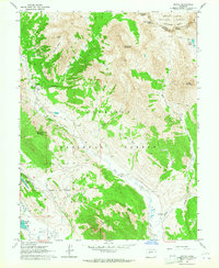
 2001 Gothic2004 Print · USGSThe high Elk Mountains of Gunnison County come into focus during the early twenty-first century as recreation and preservation intersect. Researchers can trace the layout of the Gothic settlement, locate the local Cem, and explore the backcountry reaches of Queen Basin.
 - 2011 Map of Gothic, 2011 Print
 2011 Gothic2011 Print · USGSCovers Mount Crested Butte, including Gothic, Pitkin County, and other nearby areas
 - 2013 Map of Gothic, 2013 Print
 2013 Gothic2013 Print · USGSCovers Mount Crested Butte, including Gothic, Pitkin County, and other nearby areas
 - 2016 Map of Gothic, 2016 Print
 2016 Gothic2016 Print · USGSCovers Mount Crested Butte, including Gothic, Pitkin County, and other nearby areas
 - 2019 Map of Gothic, 2019 Print
 2019 Gothic2019 Print · USGSCovers Mount Crested Butte, including Gothic, Pitkin County, and other nearby areas
 - 2022 Map of Gothic, 2022 Print
 2022 Gothic2022 Print · USGSHigh-altitude settlements and recreation trails define the Elk Mountains in the early twenty-first century. Researchers can trace land use through Gothic, Mount Crested Butte, and the Crested Butte Cem while locating landmarks like Judd Falls.
End of results
Showing maps 1-15 of 15
Top cities near Mount Crested Butte
Frequently asked questions
- What are the different types of historical maps available for Mount Crested Butte?
- What is the oldest map of Mount Crested Butte?
- Where can I purchase historical maps of Mount Crested Butte for my home or office?
- Where can I download high-res historical maps of Mount Crested Butte?
- Are there historical topographic maps available for Mount Crested Butte?
- Is there historical aerial imagery available for Mount Crested Butte?
- Where are historical maps of Mount Crested Butte sourced from?