1950s Maps of Pearl, Colorado
Explore 5 historic maps of Pearl from the 1950s. These maps offer a rare glimpse into what life looked like during the 1950s — showing old roads, neighborhoods, homes, and landmarks that have changed or disappeared over time.
Whether you're researching your family's past, planning a metal detecting trip, or studying how Pearl's landscape evolved across the 1950s, these high-resolution maps are a powerful tool for exploring the history of this region.
- Focus on a specific era: All maps on this page are from the 1950s, giving you a focused view of this time period.
- See what’s changed: Compare century-old streets, trails, and buildings to today's modern landscape using overlays and satellite layers.
- Research with precision: Use these maps for genealogy, historical research, land use analysis, or educational projects.
- View, download, or print: Maps are fully viewable online in high resolution, and can be downloaded or printed for your own records.
Start exploring Pearl's history through authentic maps from the 1950s. This is your window into the past.
Pearl, CO maps
(5)- 1954 Map of Craig, 1973 Print
 1954 Craig1973 Print · USGSNorthwest Colorado and the high mountain parks are captured in the mid-fifties, showing the region's ranching, mining, and timber centers. Genealogists and historians can trace rail corridors like the Denver and Rio Grande Western and old towns such as Axial, Milner, and Coalmont.3 unique versions available
 - 1955 Map of Pearl, 1957 Print
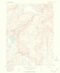 1955 Pearl1957 Print · USGSThe Colorado high country in the mid-fifties reveals a landscape of remote ranching and hard-rock mining near Pearl. Researchers can trace the water rights through the Hill Ditch and locate early operations at the Wolverine Mine and Smelter Stack.5 unique versions available
 - 1956 Map of Pearl, 1969 Print
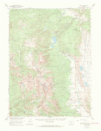 1956 Pearl1969 Print · USGSThe Colorado high country in the mid-fifties comes alive through this survey of the northern wilderness and ranchlands. Genealogists and historians can trace legacy landholdings and industry from the Smelter Stack at Pearl to isolated sites like Fort Boettcher and the Swede Group Mines.2 unique versions available
 - 1957 Map of Craig
 1957 Craig1957 Print · USGSNorthwest Colorado in the mid-fifties is a landscape of mountain ranching and rail-dependent river towns. Researchers can trace historic coal mining at the Sudduth Mine, follow the Denver and Rio Grande Western tracks, and locate vanished settlements like Pearl.
 - 1958 Map of Craig
 1958 Craig1958 Print · USGSNorthwest Colorado and the High Rockies are captured here in the mid-fifties, showing a landscape of burgeoning water projects and mountain ranching. Genealogists and historians can trace old homesteads and mountain outposts from Grand Lake to Meeker, alongside industrial landmarks like Uranium Mines and the Denver and Rio Grande Western railroad.
End of results
Showing maps 1-5 of 5
Frequently asked questions
- What are the different types of historical maps available for Pearl?
- What is the oldest map of Pearl?
- Where can I purchase historical maps of Pearl for my home or office?
- Where can I download high-res historical maps of Pearl?
- Are there historical topographic maps available for Pearl?
- Is there historical aerial imagery available for Pearl?
- Where are historical maps of Pearl sourced from?