1900-1909 Maps of Durango, Colorado
Explore 3 historic maps of Durango from 1900-1909. These maps offer a rare glimpse into what life looked like during the 1900s — showing old roads, neighborhoods, homes, and landmarks that have changed or disappeared over time.
Whether you're researching your family's past, planning a metal detecting trip, or studying how Durango's landscape evolved across the 1900s, these high-resolution maps are a powerful tool for exploring the history of this region.
- Focus on a specific era: All maps on this page are from the 1900s, giving you a focused view of this time period.
- See what’s changed: Compare century-old streets, trails, and buildings to today's modern landscape using overlays and satellite layers.
- Research with precision: Use these maps for genealogy, historical research, land use analysis, or educational projects.
- View, download, or print: Maps are fully viewable online in high resolution, and can be downloaded or printed for your own records.
Start exploring Durango's history through authentic maps from the 1900s. This is your window into the past.
Durango, CO maps
(3)- 1907 Map of Durango, 1955 Print
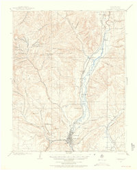 1907 Durango1955 Print · USGSLa Plata County's mining and railroad era comes to life in this survey of the Animas River corridor. Trace the early path of the Rio Grande Southern R. R. and locate historic industrial sites like the Durango Smelter and the Neglected Mine.2 unique versions available
 - 1908 Map of Ignacio
 1908 Ignacio1908 Print · USGSLa Plata County and the Southern Ute lands are captured here in the first decade of the twentieth century. Genealogists and rail historians can trace the early growth of Durango and locate rural landmarks such as the Ute Indian Agency, Pinkerton Hot Springs, and the Oxford PO.3 unique versions available
 - 1908 Map of Durango
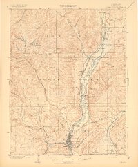 1908 Durango1908 Print · USGSDurango and the Animas River valley are shown here at a peak of industrial activity in the early 1900s. Researchers can trace the narrow-gauge Denver and Rio Grande R. R. and locate specific sites like the Durango Smelter and Boston Coal Mine.3 unique versions available
End of results
Showing maps 1-3 of 3
Frequently asked questions
- What are the different types of historical maps available for Durango?
- What is the oldest map of Durango?
- Where can I purchase historical maps of Durango for my home or office?
- Where can I download high-res historical maps of Durango?
- Are there historical topographic maps available for Durango?
- Is there historical aerial imagery available for Durango?
- Where are historical maps of Durango sourced from?