1900s (20th Century) Maps of La Junta, Colorado
Explore 10 historic maps of La Junta from the 1900s (20th Century). These maps offer a rare glimpse into what life looked like during the 1900s — showing old roads, neighborhoods, homes, and landmarks that have changed or disappeared over time.
Whether you're researching your family's past, planning a metal detecting trip, or studying how La Junta's landscape evolved across the 1900s, these high-resolution maps are a powerful tool for exploring the history of this region.
- Focus on a specific era: All maps on this page are from the 1900s, giving you a focused view of this time period.
- See what’s changed: Compare century-old streets, trails, and buildings to today's modern landscape using overlays and satellite layers.
- Research with precision: Use these maps for genealogy, historical research, land use analysis, or educational projects.
- View, download, or print: Maps are fully viewable online in high resolution, and can be downloaded or printed for your own records.
Start exploring La Junta's history through authentic maps from the 1900s. This is your window into the past.
La Junta, CO maps
(10)- 1953 Map of Cheraw, 1954 Print
 1953 Cheraw1954 Print · USGSOtero County at the start of the fifties shows a landscape reshaped by massive irrigation projects and the sugar beet industry. You can trace the railroad-dependent economy through the Sugar Refinery, locate family sites at Holbrook Cemetery, or explore the mid-century layout of Cheraw.4 unique versions available
 - 1954 Map of Lamar, 1964 Print
 1954 Lamar1964 Print · USGSSoutheastern Colorado and the Kansas borderlands appear here in the mid-fifties, dominated by the vital Arkansas River irrigation network. Researchers can trace the development of river towns like Lamar and La Junta alongside the Amity Cemetery and several major reservoirs.3 unique versions available
 - 1955 Map of La Junta, 1966 Print
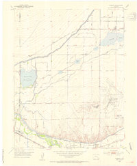
 1955 La Junta1966 Print · USGSSoutheastern Colorado during the mid-fifties is captured here as a sprawling network of ranching outposts and rail sidings. Researchers can locate vanished landmarks like the Sunderland School, trace the isolated Lycan Post Office, or find the Bomb target (abandoned) on the western plains.3 unique versions available
 - 1958 Map of La Junta
 1958 La Junta1958 Print · USGSSoutheast Colorado and the Kansas borderlands appear in the late fifties as a landscape of isolated ranching outposts and vital rail junctions. Researchers can trace the lineage of vanished post offices and rural school sites like the Lycan Post Office and Sunderland School.2 unique versions available
 - 1958 Map of Lamar
 1958 Lamar1958 Print · USGSThe High Plains of Eastern Colorado and Western Kansas in the late fifties reveal a landscape tied to the Arkansas River and the rails. Trace the heritage of the river valley through Fort Lyon, the Atchison Topeka and Santa Fe RR, and rural landmarks like Kendrick Church.2 unique versions available
 - 1966 Map of La Junta, 1970 Print
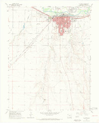 1966 La Junta1970 Print · USGSLa Junta during the mid-1960s was a bustling railroad and education hub on the Arkansas River. Historians can trace the development of neighborhood schools like Columbian Sch and Jr High Sch, or locate family sites near Fairview Cem and the Otero Jr College campus.4 unique versions available
 - 1968 Map of La Junta
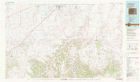
 1968 La Junta1968 Print · USGSSoutheastern Colorado and the high plains appear in remarkable detail during the late 1960s, showing the intersection of irrigation, ranching, and rail. Genealogists can trace family footprints at the Lycan Post Office, Konantz Cem, and across numerous named cattle ranches.
 - 1981 Map of Las Animas
 1981 Las Animas1981 Print · USGSSoutheast Colorado in the early eighties shows a landscape shaped by the Arkansas River and vital rail lines. Genealogists can locate family sites near La Junta, Fort Lyon, and Rocky Ford, or trace the historic path of the Santa Fe Trail.
 - 1982 Map of La Junta, 1983 Print
 1982 La Junta1983 Print · USGSSoutheast Colorado in the early eighties shows a high plains landscape defined by the historic Santa Fe Trail and the Atchison Topeka and Santa Fe rail lines. Researchers can trace rural outposts like Higbee and Timpas or the rugged canyonlands surrounding the Purgatoire River.
 - 1996 Map of La Junta, 2000 Print
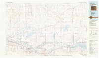
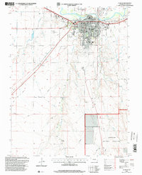 1996 La Junta2000 Print · USGSLa Junta at the close of the twentieth century shows a robust rail-and-river hub anchored by the Arkansas River. Genealogists and local historians can locate neighborhood landmarks like Fairview Cem, Lincoln Sch, and the Otero Jr College campus.
End of results
Showing maps 1-10 of 10
Top cities near La Junta
Frequently asked questions
- What are the different types of historical maps available for La Junta?
- What is the oldest map of La Junta?
- Where can I purchase historical maps of La Junta for my home or office?
- Where can I download high-res historical maps of La Junta?
- Are there historical topographic maps available for La Junta?
- Is there historical aerial imagery available for La Junta?
- Where are historical maps of La Junta sourced from?