1890s Maps of Cedar Crest, Colorado
Explore 3 historic maps of Cedar Crest from the 1890s. These maps offer a rare glimpse into what life looked like during the 1890s — showing old roads, neighborhoods, homes, and landmarks that have changed or disappeared over time.
Whether you're researching your family's past, planning a metal detecting trip, or studying how Cedar Crest's landscape evolved across the 1890s, these high-resolution maps are a powerful tool for exploring the history of this region.
- Focus on a specific era: All maps on this page are from the 1890s, giving you a focused view of this time period.
- See what’s changed: Compare century-old streets, trails, and buildings to today's modern landscape using overlays and satellite layers.
- Research with precision: Use these maps for genealogy, historical research, land use analysis, or educational projects.
- View, download, or print: Maps are fully viewable online in high resolution, and can be downloaded or printed for your own records.
Start exploring Cedar Crest's history through authentic maps from the 1890s. This is your window into the past.
Cedar Crest, CO maps
(3)- 1891 Map of Apishapa
 1891 Apishapa1891 Print · USGSSoutheastern Colorado was a land of high mesas and vital rail connections in the 1890s. Genealogists and historians can trace early rail stops like Thatcher and Delhi along the Atchison Topeka and Santa Fe Railroad.
 - 1893 Map of Apishapa
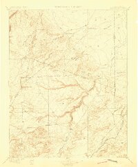
 1893 Apishapa1893 Print · USGSThe Colorado high plains of the 1890s are defined here by the winding Apishapa River and the arrival of steam power. Trace the early rail stops at Thatcher and Delhi or locate the distinctive volcanic landmarks of the Rattlesnake Buttes.
 - 1897 Map of Apishapa
 1897 Apishapa1897 Print · USGSSoutheastern Colorado appears here during the cattle-ranching era of the late nineteenth century. Researchers can trace the legacy of early western transit along the Santa Fe Trail or locate family landmarks like the Baca Ranch and Thatcher.4 unique versions available
End of results
Showing maps 1-3 of 3
Frequently asked questions
- What are the different types of historical maps available for Cedar Crest?
- What is the oldest map of Cedar Crest?
- Where can I purchase historical maps of Cedar Crest for my home or office?
- Where can I download high-res historical maps of Cedar Crest?
- Are there historical topographic maps available for Cedar Crest?
- Is there historical aerial imagery available for Cedar Crest?
- Where are historical maps of Cedar Crest sourced from?