1950s Maps of Woodland Park, Colorado
Explore 8 historic maps of Woodland Park from the 1950s. These maps offer a rare glimpse into what life looked like during the 1950s — showing old roads, neighborhoods, homes, and landmarks that have changed or disappeared over time.
Whether you're researching your family's past, planning a metal detecting trip, or studying how Woodland Park's landscape evolved across the 1950s, these high-resolution maps are a powerful tool for exploring the history of this region.
- Focus on a specific era: All maps on this page are from the 1950s, giving you a focused view of this time period.
- See what’s changed: Compare century-old streets, trails, and buildings to today's modern landscape using overlays and satellite layers.
- Research with precision: Use these maps for genealogy, historical research, land use analysis, or educational projects.
- View, download, or print: Maps are fully viewable online in high resolution, and can be downloaded or printed for your own records.
Start exploring Woodland Park's history through authentic maps from the 1950s. This is your window into the past.
Woodland Park, CO maps
(8)- 1953 Map of Denver, 1964 Print
 1953 Denver1964 Print · USGSDenver and the Colorado Front Range are captured here during a decade of post-war growth and military expansion. Researchers can trace the sprawling rail lines of the Union Pacific, locate the State Capitol, and explore historic mountain mining hubs like Central City.6 unique versions available
 - 1954 Map of Mount Deception, 1955 Print
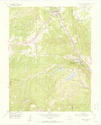
 1954 Mount Deception1955 Print · USGSThe Pike National Forest comes to life in the mid-fifties, showing a landscape of forest research and early mountain recreation. Researchers can trace historic sites like the Manitou Experimental Forest Headquarters, the Manitou Park Grange, and the Sky High Girl Scout Camp.10 unique versions available
 - 1954 Map of Woodland Park, 1955 Print
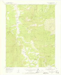
 1954 Woodland Park1955 Print · USGSWoodland Park and the surrounding Rampart Range are shown in the mid-1950s as mountain tourism and water infrastructure expanded. Trace the Colorado Midland Railroad (Former Grade) or locate landmarks like The Crags and Thunderbird Camp.6 unique versions available
 - 1954 Map of Pueblo, 1966 Print
 1954 Pueblo1966 Print · USGSMid-century Colorado comes alive in this survey of the Front Range and the high plains as the region expanded after the war. Genealogists and historians can trace family roots through rural landmarks like Hanover Church, Pioneer Cemetery, and the Grandview School.3 unique versions available
 - 1957 Map of Denver
 1957 Denver1957 Print · USGSDenver and the Colorado Front Range are seen here during a mid-century period of intense military and urban expansion. Trace the footprints of the Rocky Mountain Arsenal, the early United States Air Force Academy, and the Lowry AF Base.
 - 1957 Map of Pueblo
 1957 Pueblo1957 Print · USGSMid-century Colorado comes alive as the Front Range urban centers expand alongside massive Cold War military installations. Genealogists and historians can trace the foundations of Stone City, rural sites like Hanover School, and the industrial Canon Imperial Mine.
 - 1958 Map of Pueblo
 1958 Pueblo1958 Print · USGSColorado's Front Range and Arkansas River Valley come alive in the late fifties, showing the transition from historic mining districts to major military and rail hubs. Genealogists and historians can trace family roots in ranching communities and find landmarks like Cripple Creek, Manitou, and the Hanover School.
 - 1958 Map of Denver
 1958 Denver1958 Print · USGSDenver and the Colorado Front Range are captured here during the mid-century suburban boom. Trace the footprints of military installations like Buckley Air Force Base alongside the established rail networks of the Colorado & Southern Ry.
End of results
Showing maps 1-8 of 8
Top cities near Woodland Park
- Colorado Springs historical maps
- Manitou Springs historical maps
- Monument historical maps
- Palmer Lake historical maps
- Green Mountain Falls historical maps
- Larkspur historical maps
See more
Frequently asked questions
- What are the different types of historical maps available for Woodland Park?
- What is the oldest map of Woodland Park?
- Where can I purchase historical maps of Woodland Park for my home or office?
- Where can I download high-res historical maps of Woodland Park?
- Are there historical topographic maps available for Woodland Park?
- Is there historical aerial imagery available for Woodland Park?
- Where are historical maps of Woodland Park sourced from?