1940s Maps of Berlin, Connecticut
Explore 6 historic maps of Berlin from the 1940s. These maps offer a rare glimpse into what life looked like during the 1940s — showing old roads, neighborhoods, homes, and landmarks that have changed or disappeared over time.
Whether you're researching your family's past, planning a metal detecting trip, or studying how Berlin's landscape evolved across the 1940s, these high-resolution maps are a powerful tool for exploring the history of this region.
- Focus on a specific era: All maps on this page are from the 1940s, giving you a focused view of this time period.
- See what’s changed: Compare century-old streets, trails, and buildings to today's modern landscape using overlays and satellite layers.
- Research with precision: Use these maps for genealogy, historical research, land use analysis, or educational projects.
- View, download, or print: Maps are fully viewable online in high resolution, and can be downloaded or printed for your own records.
Start exploring Berlin's history through authentic maps from the 1940s. This is your window into the past.
Berlin, CT maps
(6)- 1944 Map of Hartford South
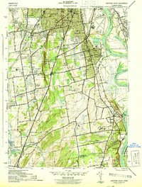 1944 Hartford South1944 Print · USGSThe southern Hartford suburbs and Wethersfield are mapped here during the mid-forties, capturing the region's dense institutional and rail network. Genealogists and local historians can trace family locations near Old South Cem or identify wartime landmarks like Bulkeley Stadium and the State Prison.3 unique versions available
 - 1945 Map of Middletown
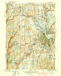 1945 Middletown1945 Print · USGSThe industrial and academic heart of the Connecticut River valley is captured here in the mid-1940s. Genealogists and historians can trace the campuses of Wesleyan University, local institutions like the Swedish Orphanage, and neighborhood landmarks in South Farms.2 unique versions available
 - 1946 Map of Meriden
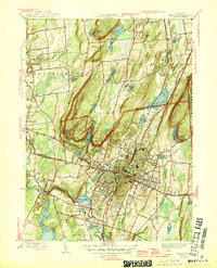 1946 Meriden1946 Print · USGSThe industrial corridor of Central Connecticut comes alive in the mid-1940s, showing the dense development of Meriden and its surrounding ridge lines. Genealogists can locate family sites near St Thomas Cem and Stillmans Corner or trace the early footprint of Meriden Airport.2 unique versions available
 - 1946 Map of New Britain
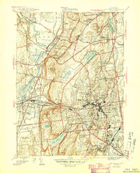 1946 New Britain1946 Print · USGSMid-century Hartford County shows a landscape of growing suburbs and deep-rooted institutions centered on the city of New Britain. Researchers can trace old neighborhood boundaries and find local landmarks like the Polish Orphanage St Lucien Home and Fairview Cem.2 unique versions available
 - 1947 Map of Hartford, 1955 Print
 1947 Hartford1955 Print · USGSSouthern New England and the Hudson Valley are shown in detail during the post-war expansion era. Genealogists and researchers can trace local landmarks from the State Capitol and Yale University to the Stratford Lighthouse and Woodlawn Cem.2 unique versions available
 - 1948 Map of Hartford
 1948 Hartford1948 Print · USGSSouthern New England is captured here in the late 1940s, showcasing a landscape of thriving industrial cities and developing parkways. Genealogists and historians can trace the rail networks of the New York New Haven and Hartford RR or locate coastal defense sites like Fort Terry and Camp Shanks.2 unique versions available
End of results
Showing maps 1-6 of 6
Top cities near Berlin
- Hartford historical maps
- Waterbury historical maps
- New Britain historical maps
- West Hartford historical maps
- Meriden historical maps
- Bristol historical maps
See more
Top neighborhoods of Berlin
- East Berlin historical maps
- Kensington historical maps
- Turkey Hill historical maps
- Worthington Ridge Historic District historical maps
Frequently asked questions
- What are the different types of historical maps available for Berlin?
- What is the oldest map of Berlin?
- Where can I purchase historical maps of Berlin for my home or office?
- Where can I download high-res historical maps of Berlin?
- Are there historical topographic maps available for Berlin?
- Is there historical aerial imagery available for Berlin?
- Where are historical maps of Berlin sourced from?