1950s Maps of Mansfield, Connecticut
Explore 4 historic maps of Mansfield from the 1950s. These maps offer a rare glimpse into what life looked like during the 1950s — showing old roads, neighborhoods, homes, and landmarks that have changed or disappeared over time.
Whether you're researching your family's past, planning a metal detecting trip, or studying how Mansfield's landscape evolved across the 1950s, these high-resolution maps are a powerful tool for exploring the history of this region.
- Focus on a specific era: All maps on this page are from the 1950s, giving you a focused view of this time period.
- See what’s changed: Compare century-old streets, trails, and buildings to today's modern landscape using overlays and satellite layers.
- Research with precision: Use these maps for genealogy, historical research, land use analysis, or educational projects.
- View, download, or print: Maps are fully viewable online in high resolution, and can be downloaded or printed for your own records.
Start exploring Mansfield's history through authentic maps from the 1950s. This is your window into the past.
Mansfield, CT maps
(4)- 1953 Map of Willimantic, 1954 Print
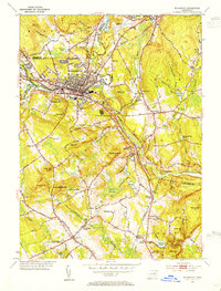 1953 Willimantic1954 Print · USGSWillimantic and its surrounding hill country are captured here in the early fifties, showing a bustling rail junction at the height of its mid-century character. Trace the routes of the Central Vermont Railway, find the historic Trumbull Cem, or locate the old Willimantic State Teachers College.5 unique versions available
 - 1953 Map of South Coventry, 1955 Print
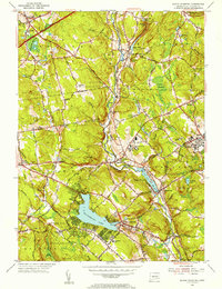 1953 South Coventry1955 Print · USGSTolland County in the early fifties shows a landscape of developing university grounds and historic rural villages. Genealogists can trace family landmarks like the Nathan Hale Birthplace or follow the Central Vermont Railway past Mansfield Depot and Eagleville Lake.5 unique versions available
 - 1953 Map of Spring Hill, 1955 Print
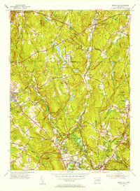 1953 Spring Hill1955 Print · USGSTolland and Windham counties are shown in the early fifties as the University of Connecticut expanded within a landscape of traditional hill towns. Trace ancestral roots through rural landmarks like Wormwood Hill Cem, the crossroads at Bedlam Corner, and the old rail line at North Windham.4 unique versions available
 - 1953 Map of Columbia, 1955 Print
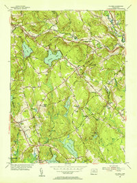 1953 Columbia1955 Print · USGSTolland County and its surrounding highlands appear here in the mid-1950s, a period when rural schoolhouses and family cemeteries still anchored the community. Genealogists can locate family landmarks like Utley Hill Cem, Porter Sch, and the rail stops along the New York and New Haven and Hartford Railroad.6 unique versions available
End of results
Showing maps 1-4 of 4
Top cities near Mansfield
- Norwich historical maps
- Glastonbury historical maps
- Vernon historical maps
- Windham historical maps
- Willimantic historical maps
- Storrs historical maps
See more
Top neighborhoods of Mansfield
- Perkins Corner historical maps
- Atwoodville historical maps
- Chaffeeville historical maps
- Wormwood Hill historical maps
- Mansfield City historical maps
- Merrow historical maps
See more
Frequently asked questions
- What are the different types of historical maps available for Mansfield?
- What is the oldest map of Mansfield?
- Where can I purchase historical maps of Mansfield for my home or office?
- Where can I download high-res historical maps of Mansfield?
- Are there historical topographic maps available for Mansfield?
- Is there historical aerial imagery available for Mansfield?
- Where are historical maps of Mansfield sourced from?