1890s Maps of Clinton, Connecticut
Explore 2 historic maps of Clinton from the 1890s. These maps offer a rare glimpse into what life looked like during the 1890s — showing old roads, neighborhoods, homes, and landmarks that have changed or disappeared over time.
Whether you're researching your family's past, planning a metal detecting trip, or studying how Clinton's landscape evolved across the 1890s, these high-resolution maps are a powerful tool for exploring the history of this region.
- Focus on a specific era: All maps on this page are from the 1890s, giving you a focused view of this time period.
- See what’s changed: Compare century-old streets, trails, and buildings to today's modern landscape using overlays and satellite layers.
- Research with precision: Use these maps for genealogy, historical research, land use analysis, or educational projects.
- View, download, or print: Maps are fully viewable online in high resolution, and can be downloaded or printed for your own records.
Start exploring Clinton's history through authentic maps from the 1890s. This is your window into the past.
Clinton, CT maps
(2)- 1893 Map of Guilford
 1893 Guilford1893 Print · USGSCoastal Middlesex County comes to life in the late nineteenth century, showing the early rail-connected growth of shoreline and interior villages. Genealogists can trace family landmarks and forgotten stops like Sachems Head Station, Nut Plains, and Nineveh Falls.8 unique versions available
 - 1893 Map of Saybrook, 1898 Print
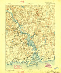 1893 Saybrook1898 Print · USGSThe Lower Connecticut River valley in the 1890s was a bustling corridor of maritime landings and burgeoning rail junctions. Genealogists and historians can trace the foundations of Old Saybrook, the industrial roots of Ivoryton, and river landings like Goodspeed Landing.8 unique versions available
End of results
Showing maps 1-2 of 2
Top cities near Clinton
- Brookhaven historical maps
- Meriden historical maps
- Middletown historical maps
- Wallingford historical maps
- Riverhead historical maps
- Branford historical maps
See more
Top neighborhoods of Clinton
- Clinton Beach historical maps
- Duck Island Roads historical maps
- Kelseytown historical maps
- Ridgewood historical maps
- Harbor View historical maps
Frequently asked questions
- What are the different types of historical maps available for Clinton?
- What is the oldest map of Clinton?
- Where can I purchase historical maps of Clinton for my home or office?
- Where can I download high-res historical maps of Clinton?
- Are there historical topographic maps available for Clinton?
- Is there historical aerial imagery available for Clinton?
- Where are historical maps of Clinton sourced from?