1940s Maps of Haddam, Connecticut
Explore 7 historic maps of Haddam from the 1940s. These maps offer a rare glimpse into what life looked like during the 1940s — showing old roads, neighborhoods, homes, and landmarks that have changed or disappeared over time.
Whether you're researching your family's past, planning a metal detecting trip, or studying how Haddam's landscape evolved across the 1940s, these high-resolution maps are a powerful tool for exploring the history of this region.
- Focus on a specific era: All maps on this page are from the 1940s, giving you a focused view of this time period.
- See what’s changed: Compare century-old streets, trails, and buildings to today's modern landscape using overlays and satellite layers.
- Research with precision: Use these maps for genealogy, historical research, land use analysis, or educational projects.
- View, download, or print: Maps are fully viewable online in high resolution, and can be downloaded or printed for your own records.
Start exploring Haddam's history through authentic maps from the 1940s. This is your window into the past.
Haddam, CT maps
(7)- 1943 Map of Durham
 1943 Durham1943 Print · USGSMiddlesex and New Haven counties are mapped during the early years of the war, showing the rural landscapes around Durham Center. Genealogists and historians can trace family-named sites like Linmar Dairy Farm and explore the rail corridor of the New York New Haven and Hartford.
 - 1944 Map of Deep River
 1944 Deep River1944 Print · USGSMid-century Middlesex County life is centered on the Connecticut River as the region's primary artery for transport and industry. Researchers can trace the paths of the New York New Haven and Hartford Railroad and locate ancestral burial sites like Old Cove Burying Ground or the Mt Parnassus Burying Ground.2 unique versions available
 - 1945 Map of Middle Haddam
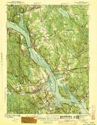
 1945 Middle Haddam1945 Print · USGSMiddlesex County life along the river comes into focus in the 1940s as the railroad connects riverside mill towns. Genealogists and historians can trace family roots through the Portland Burying Ground, Eureka Mill, and the riverside Middle Haddam.2 unique versions available
 - 1945 Map of Middletown
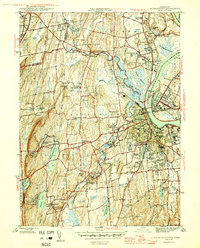 1945 Middletown1945 Print · USGSThe industrial and academic heart of the Connecticut River valley is captured here in the mid-1940s. Genealogists and historians can trace the campuses of Wesleyan University, local institutions like the Swedish Orphanage, and neighborhood landmarks in South Farms.2 unique versions available
 - 1946 Map of Moodus
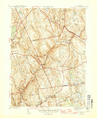 1946 Moodus1946 Print · USGSMiddlesex and New London counties are captured here just after the war, showing a network of river-powered villages and rural school districts. Researchers can locate family landmarks such as the Jones St Sch, Ponemah Cem, and the historic Comstock Bridge.2 unique versions available
 - 1947 Map of Hartford, 1955 Print
 1947 Hartford1955 Print · USGSSouthern New England and the Hudson Valley are shown in detail during the post-war expansion era. Genealogists and researchers can trace local landmarks from the State Capitol and Yale University to the Stratford Lighthouse and Woodlawn Cem.2 unique versions available
 - 1948 Map of Hartford
 1948 Hartford1948 Print · USGSSouthern New England is captured here in the late 1940s, showcasing a landscape of thriving industrial cities and developing parkways. Genealogists and historians can trace the rail networks of the New York New Haven and Hartford RR or locate coastal defense sites like Fort Terry and Camp Shanks.2 unique versions available
End of results
Showing maps 1-7 of 7
Top cities near Haddam
- New Britain historical maps
- Meriden historical maps
- Middletown historical maps
- Wallingford historical maps
- Glastonbury historical maps
- Newington historical maps
See more
Top neighborhoods of Haddam
- Shailerville historical maps
- Tylerville historical maps
- Arnolds historical maps
- West Haddam historical maps
- Haddam Neck historical maps
- Higganum historical maps
See more
Frequently asked questions
- What are the different types of historical maps available for Haddam?
- What is the oldest map of Haddam?
- Where can I purchase historical maps of Haddam for my home or office?
- Where can I download high-res historical maps of Haddam?
- Are there historical topographic maps available for Haddam?
- Is there historical aerial imagery available for Haddam?
- Where are historical maps of Haddam sourced from?