1950s Maps of Lyme, Connecticut
Explore 5 historic maps of Lyme from the 1950s. These maps offer a rare glimpse into what life looked like during the 1950s — showing old roads, neighborhoods, homes, and landmarks that have changed or disappeared over time.
Whether you're researching your family's past, planning a metal detecting trip, or studying how Lyme's landscape evolved across the 1950s, these high-resolution maps are a powerful tool for exploring the history of this region.
- Focus on a specific era: All maps on this page are from the 1950s, giving you a focused view of this time period.
- See what’s changed: Compare century-old streets, trails, and buildings to today's modern landscape using overlays and satellite layers.
- Research with precision: Use these maps for genealogy, historical research, land use analysis, or educational projects.
- View, download, or print: Maps are fully viewable online in high resolution, and can be downloaded or printed for your own records.
Start exploring Lyme's history through authentic maps from the 1950s. This is your window into the past.
Lyme, CT maps
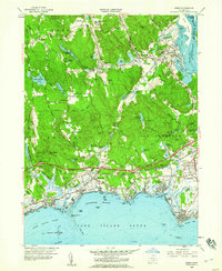
(5)- 1951 Map of Lyme
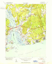 1951 Lyme1951 Print · USGSThe Connecticut shoreline at the start of the fifties shows a transition from quiet rural hills to bustling beach colonies. Trace family roots and local history at the Duck River Cem, Lynde Pt Lighthouse, and the Lyme Sta railroad stop.2 unique versions available
 - 1952 Map of Deep River, 1953 Print
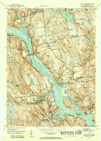 1952 Deep River1953 Print · USGSMiddlesex County life in the early fifties is centered on the river and rail lines between Moodus and Deep River. Genealogists and historians can trace family roots through numerous local landmarks like Hearse Hill Cem, Parker Cem, and Johnson Mill.3 unique versions available
 - 1952 Map of Hamburg, 1954 Print
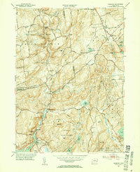 1952 Hamburg1954 Print · USGSIn the early 1950s, this pocket of New London County remained a landscape of dense state forests and scattered farmsteads. Researchers can trace numerous family burial sites like Millington Cem or explore the grounds of the Yale Engineering Camp and Devils Hopyard State Park.3 unique versions available
 - 1958 Map of Old Lyme, 1959 Print
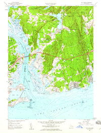 1958 Old Lyme1959 Print · USGSThe Connecticut shoreline transitions into a new era of travel just as the turnpike is being established near Old Lyme. Genealogists and historians can trace family plots at Duck River Cem or locate the old Lyme Station along the rail line.6 unique versions available
 - 1958 Map of Essex, 1960 Print
 1958 Essex1960 Print · USGSThe Connecticut coast at the end of the fifties reveals a landscape of tidal coves and growing shoreline communities. Genealogists and historians can trace family-named sites like Mares Hill, locate the Central Burying Ground, and follow the path of the New York New Haven and Hartford railroad.5 unique versions available
End of results
Showing maps 1-5 of 5
Top cities near Lyme
- Middletown historical maps
- Norwich historical maps
- East Hampton historical maps
- Southold historical maps
- Montville historical maps
- Waterford historical maps
See more
Top neighborhoods of Lyme
- Brockway Landing historical maps
- Hadlyme historical maps
- Hamburg historical maps
- North Lyme historical maps
- Sterling City historical maps
- Brockway historical maps
See more
Frequently asked questions
- What are the different types of historical maps available for Lyme?
- What is the oldest map of Lyme?
- Where can I purchase historical maps of Lyme for my home or office?
- Where can I download high-res historical maps of Lyme?
- Are there historical topographic maps available for Lyme?
- Is there historical aerial imagery available for Lyme?
- Where are historical maps of Lyme sourced from?