Old Maps of Plymouth, Connecticut for Genealogy
Trace your family roots with 38 historic maps of Plymouth. These high-res maps reveal old neighborhoods, homesites, landmarks, and streets — helping you uncover where your ancestors lived and how the area evolved over time.
- Explore historic neighborhoods: Identify where your relatives may have lived in the 1800s or 1900s.
- Compare maps over time: Trace the changes in streets, buildings, and landmarks for multi-generational research.
- Perfect for genealogy & ancestry research: Used by family historians and researchers to map out lineage and migration.
These maps are an incredible resource for exploring your personal connection to Plymouth's past.
Plymouth, CT maps
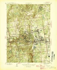
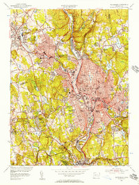
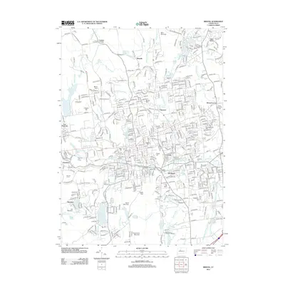
(38)- 1892 Map of Meriden
 1892 Meriden1892 Print · USGSCentral Connecticut in the late Victorian era shows a thriving network of industrial towns and ridge-line reservoirs connected by major rail lines. Genealogists and historians can trace family roots and old homesteads near Terryville, Plainville, and Milldale.
 - 1893 Map of Waterbury
 1893 Waterbury1893 Print · USGSWestern Connecticut in the late nineteenth century was defined by the industrial pulse of the Naugatuck valley and the quiet hills to its west. Genealogists and historians can trace the early rail alignments of the Northern R. R. and locate family landmarks like White Deer Rocks or the village of Hotchkissville.2 unique versions available
 - 1893 Map of Meriden
 1893 Meriden1893 Print · USGSCentral Connecticut at the end of the 19th century was a booming landscape of industrial centers and vital rail junctions. Genealogists and local historians can trace the early street grids and neighborhoods of Meriden, find vanished stops like Southington Road Sta., or locate family roots in Kensington and Forestville.10 unique versions available
 - 1904 Map of Waterbury
 1904 Waterbury1904 Print · USGSThe Naugatuck River valley's industrial peak and the surrounding Litchfield Hills are captured here at the start of the twentieth century. Researchers can trace the early rail networks of the Naugatuck Division and find old local landmarks like Reynolds Bridge, Quassapaug Pond, and Hotchkissville.8 unique versions available
 - 1904 Map of Litchfield
 1904 Litchfield1904 Print · USGSThe Litchfield Hills at the turn of the century are shown here as a landscape of iron heritage and river-powered industry. Genealogists and historians can locate old industrial sites like Kent Furnace, ancestral homes near Sharon Valley, and early rail stops at Limerock Sta..3 unique versions available
 - 1906 Map of Farmington
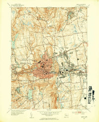
 1906 Farmington1906 Print · USGSCentral Connecticut at the turn of the century is a landscape of river-powered industry and rail-connected towns. Researchers can trace historic river crossings like Bissell Ferry and explore early village centers including Collinsville, Satans Kingdom, and Pine Meadow.2 unique versions available
 - 1946 Map of Bristol
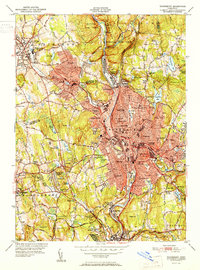
 1946 Bristol1946 Print · USGSPost-war Bristol and its surrounding townships show a thriving landscape of manufacturing and close-knit neighborhoods. Genealogists and local historians can trace long-standing landmarks from the Methodist Campground and St Josephs Cem to historic recreation at Lake Compounce.
 - 1947 Map of Hartford, 1955 Print
 1947 Hartford1955 Print · USGSSouthern New England and the Hudson Valley are shown in detail during the post-war expansion era. Genealogists and researchers can trace local landmarks from the State Capitol and Yale University to the Stratford Lighthouse and Woodlawn Cem.2 unique versions available
 - 1948 Map of Hartford
 1948 Hartford1948 Print · USGSSouthern New England is captured here in the late 1940s, showcasing a landscape of thriving industrial cities and developing parkways. Genealogists and historians can trace the rail networks of the New York New Haven and Hartford RR or locate coastal defense sites like Fort Terry and Camp Shanks.2 unique versions available
 - 1951 Map of Thomaston
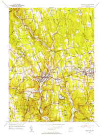
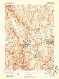 1951 Thomaston1951 Print · USGSMid-century Litchfield County unfolds along the industrial Naugatuck valley and the rising Litchfield Hills during a period of steady growth. Genealogists and historians can locate numerous family burial grounds including Allentown Cem, trace the New York New Haven and Hartford rail lines, or find the Leatherman Cave.2 unique versions available
 - 1951 Map of Waterbury
 1951 Waterbury1951 Print · USGSMid-century New Haven County is captured here at a moment of dense urban growth and industrial activity along the Naugatuck River. Genealogists and researchers can pinpoint family landmarks from Riverside Cemetery to the Brookside Home for the Aged and numerous parochial and public schools.2 unique versions available
 - 1953 Map of Bristol, 1954 Print
 1953 Bristol1954 Print · USGSPost-war Bristol and its surrounding hills are captured here in transition from an industrial hub to a suburban landscape. Genealogists can trace family plots at St Josephs Cem or locate old neighborhood landmarks like Stafford Sch and Lake Compounce.3 unique versions available
 - 1955 Map of Waterbury, 1957 Print
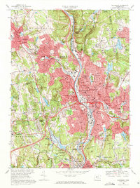
 1955 Waterbury1957 Print · USGSWaterbury and the Naugatuck Valley are shown here during a period of significant post-war growth and industrial activity. Researchers can trace historic institutions and neighborhoods from Riverside Cemetery to the Taft Sch and the New York New Haven and Hartford RR corridor.2 unique versions available
 - 1956 Map of Thomaston, 1957 Print
 1956 Thomaston1957 Print · USGSLitchfield County's industrial river valleys and wooded uplands are captured here in the mid-fifties, showing the intersection of rail, water, and town life. Trace the path of the New York New Haven and Hartford railroad through Thomaston or locate old community landmarks like Eagle Rock Ch and the Terryville Tunnel.7 unique versions available
 - 1961 Map of Hartford
 1961 Hartford1961 Print · USGSSouthern New England and the Hudson Valley are shown here in the mid-fifties, capturing a landscape of booming coastal cities and interior hill towns. Researchers can trace the legacy of the New York New Haven and Hartford rail corridor and find strategic sites like Camp Shanks and Fort Michie.
 - 1962 Map of Hartford, 1971 Print
 1962 Hartford1971 Print · USGSSouthern New England and the Hudson Valley are shown in the early sixties, as suburban growth reached into the foothills. Trace the path of the New York New Haven & Hartford RR and find landmarks like Camp Nathan Hale and Gillette Castle State Park.3 unique versions available
 - 1965 Map of Hartford
 1965 Hartford1965 Print · USGSSouthern New England and the Hudson Valley are shown here during the mid-sixties expansion of the Interstate era. Trace the path of the New York New Haven & Hartford RR or locate historic landmarks like West Point Military Reservation and the Merritt Parkway.2 unique versions available
 - 1966 Map of Bristol, 1968 Print
 1966 Bristol1968 Print · USGSMid-century Bristol and Farmington show a landscape of growing suburbs and industrial heritage along the Pequabuck River. Genealogists and historians can trace neighborhood development near Forestville, local recreation at Lake Compounce, and parish schools like St Josephs Sch.4 unique versions available
 - 1968 Map of Waterbury, 1971 Print
 1968 Waterbury1971 Print · USGSWaterbury and Watertown appear here during a period of significant suburban expansion and highway development in the late sixties. Genealogists and local historians can trace family plots in Riverside Cemetery or locate historic institutions like the Taft School and Waterbury State Technical Institute.4 unique versions available
 - 1985 Map of Waterbury, 1986 Print
 1985 Waterbury1986 Print · USGSThe Western Connecticut highlands and the Hudson Valley are captured in the mid-1980s, showing a landscape of deep forests and industrial river towns. Genealogists can trace family connections from Waterbury up through Litchfield and Torrington, while exploring the vast Barkhamsted Reservoir and Candlewood Lake basins.
 - 1986 Map of Hartford
 1986 Hartford1986 Print · USGSCentral Connecticut and the surrounding highlands were undergoing significant suburban growth and industrial transition during the mid-eighties. Researchers can trace the layout of regional landmarks including Bradley International Airport, the University of Connecticut, and the historic State Capitol.
 - 1993 Map of Waterbury
 1993 Waterbury1993 Print · USGSWestern Connecticut and the Hudson Valley appear in the early nineties as a landscape of established industrial cities and deep forest preserves. Researchers can trace the rail corridors of the Metro-North Railroad or locate family sites near the Taft School and Riverside Cemetery.
 - 1994 Map of Hartford, 1995 Print
 1994 Hartford1995 Print · USGSGreater Hartford and the Connecticut River Valley are captured here in the mid-nineties, showing the dense intersection of industry and academia. Trace the urban footprint of the State Capitol and Trinity College or locate the sprawling grounds of the University of Connecticut.2 unique versions available
 - 2012 Map of Bristol, 2012 Print
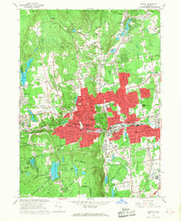
 2012 Bristol2012 Print · USGSCovers Plymouth, including Bristol, Southington, and other nearby areas
 - 2012 Map of Thomaston, 2012 Print
 2012 Thomaston2012 Print · USGSCovers Plymouth, including Watertown, Wolcott, and other nearby areas
Showing maps 1-25 of 38
Top cities near Plymouth
- Waterbury historical maps
- New Britain historical maps
- West Hartford historical maps
- Meriden historical maps
- Bristol historical maps
- Hamden historical maps
See more
Top neighborhoods of Plymouth
- East Plymouth historical maps
- Terryville historical maps
- Tolles historical maps
- Allentown historical maps
- Hancock historical maps
- Pequabuck historical maps
See more
Frequently asked questions
- What are the different types of historical maps available for Plymouth?
- What is the oldest map of Plymouth?
- Where can I purchase historical maps of Plymouth for my home or office?
- Where can I download high-res historical maps of Plymouth?
- Are there historical topographic maps available for Plymouth?
- Is there historical aerial imagery available for Plymouth?
- Where are historical maps of Plymouth sourced from?