Old Maps of South Central Connecticut Planning Region, Connecticut
Explore 145 old maps of South Central Connecticut Planning Region, spanning from 1889 to today. These high-resolution historic maps reveal how streets, neighborhoods, landmarks, and natural features evolved over time — perfect for genealogy, metal detecting, research, and local history exploration.
What you can do with these maps:
- See how South Central Connecticut Planning Region changed over time: Compare historical maps to modern-day views to trace roads, homesites, rail lines & more.
- View detailed metadata: Each map includes creators, publishers, year, scale, and archive source.
- Overlay maps with satellite & LiDAR: Visualize the past alongside modern tools to explore terrain & human change.
- Trusted historical sources: Maps sourced from the USGS, Library of Congress, and other archives.
- Access maps your way: View online, download high-res files, or order prints for personal or research use.
Start exploring old maps of South Central Connecticut Planning Region to uncover forgotten places, hidden landmarks, and the deep history beneath your feet.
South Central Connecticut Planning Region, CT maps
(145)- 1889 Map of Derby
 1889 Derby1889 Print · USGSThe industrial Naugatuck Valley hums with activity in the late Victorian era as railroads and river power drive the growth of Connecticut's mill towns. Genealogists can trace family holdings near John Johnson Hill or explore the early street layouts of BIRMINGHAM, ANSONIA, and SEYMOUR.
 - 1891 Map of Bridgeport
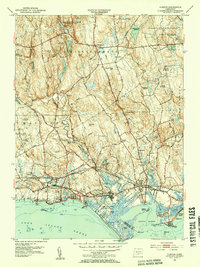
 1891 Bridgeport1891 Print · USGSThe industrial shoreline of Fairfield County comes to life in this late Victorian survey, capturing the region's intense rail and maritime activity. Trace the early street grids of Bridgeport and Milford, or locate family landmarks near Moodys Mill Pond and Nichols Farms.
 - 1891 Map of Derby
 1891 Derby1891 Print · USGSThe industrial Naugatuck Valley and the rural hills of Oxford come to life in the late nineteenth century. Genealogists and historians can trace the early footprints of Birmingham, Ansonia, and Derby or locate outlying hamlets like Quaker Farms and Red City.
 - 1892 Map of New Haven
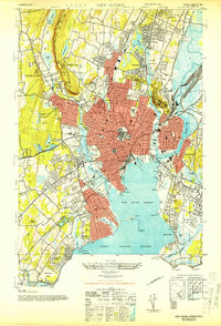
 1892 New Haven1892 Print · USGSNew Haven and its coastal surrounds are captured here during a peak era of rail-and-maritime trade. Genealogists and historians can trace the early industrial development of Whitneyville, the shorefront at Savin Rock, and the strategic position of Fort Hale.13 unique versions available
 - 1892 Map of Meriden
 1892 Meriden1892 Print · USGSCentral Connecticut in the late Victorian era shows a thriving network of industrial towns and ridge-line reservoirs connected by major rail lines. Genealogists and historians can trace family roots and old homesteads near Terryville, Plainville, and Milldale.
 - 1893 Map of Bridgeport
 1893 Bridgeport1893 Print · USGSCoastal Connecticut thrived in the 1890s as a hub of manufacturing and rail transport. Genealogists and historians can trace the early street grids of Bridgeport, find old landmarks like Berkshire Mill Pond, and locate family sites in Nichols Farms.8 unique versions available
 - 1893 Map of Guilford
 1893 Guilford1893 Print · USGSCoastal Middlesex County comes to life in the late nineteenth century, showing the early rail-connected growth of shoreline and interior villages. Genealogists can trace family landmarks and forgotten stops like Sachems Head Station, Nut Plains, and Nineveh Falls.8 unique versions available
 - 1893 Map of Middletown
 1893 Middletown1893 Print · USGSThe Connecticut River valley was a bustling corridor of industry and iron rails in the early 1890s. Genealogists and historians can trace the early streets of Middletown, the riverside docks at Portland, and the sprawling State Prison grounds in Wethersfield.10 unique versions available
 - 1893 Map of Meriden
 1893 Meriden1893 Print · USGSCentral Connecticut at the end of the 19th century was a booming landscape of industrial centers and vital rail junctions. Genealogists and local historians can trace the early street grids and neighborhoods of Meriden, find vanished stops like Southington Road Sta., or locate family roots in Kensington and Forestville.10 unique versions available
 - 1893 Map of Derby, 1898 Print
 1893 Derby1898 Print · USGSLower Naugatuck Valley industry and rural hill towns are captured in detail during the 1890s as the rail network reached its peak. Researchers can trace the industrial hearts of Birmingham and Derby or locate old crossings like Zoar Bridge and Pines Bridge.9 unique versions available
 - 1906 Map of Farmington
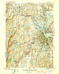
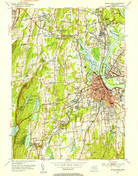
 1906 Farmington1906 Print · USGSCentral Connecticut at the turn of the century is a landscape of river-powered industry and rail-connected towns. Researchers can trace historic river crossings like Bissell Ferry and explore early village centers including Collinsville, Satans Kingdom, and Pine Meadow.2 unique versions available
 - 1920 Map of Bridgeport
 1920 Bridgeport1920 Print · USGSCoastal Connecticut comes alive in the early twentieth century as a hub of maritime commerce and industrial growth. Researchers can trace the development of Bridgeport and Milford, or locate specific landmarks like Charles Island and Beardsley Park.
 - 1921 Map of New Haven
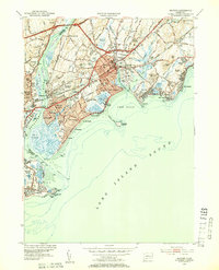
 1921 New Haven1921 Print · USGSNew Haven and its harbor appear in the early twenties as a thriving industrial and maritime hub. Genealogists and historians can trace rail-era neighborhoods and shoreline landmarks like Savin Rock, Fair Haven, and the Mt. Carmel Sta. depot.
 - 1928 Map of Cromwell
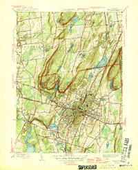
 1928 Cromwell1928 Print · USGSMiddlesex County emerges in high detail during the late Prohibition era as aerial photography began to modernize American cartography. Researchers can trace the rail lines of the New York New Haven and Hartford through Rockfall, Westfield, and the waterfront at Willow Island.
 - 1943 Map of Durham
 1943 Durham1943 Print · USGSMiddlesex and New Haven counties are mapped during the early years of the war, showing the rural landscapes around Durham Center. Genealogists and historians can trace family-named sites like Linmar Dairy Farm and explore the rail corridor of the New York New Haven and Hartford.
 - 1943 Map of New Haven, 1947 Print
 1943 New Haven1947 Print · USGSGreater New Haven at the height of the mid-forties reveals a thriving industrial port city and academic center. Researchers can trace the legacy of Yale University, locate the amusement piers of Savin Rock, and explore the shoreline from Sandy Pt to the New Haven Airport.2 unique versions available
 - 1943 Map of Naugatuck, 1947 Print
 1943 Naugatuck1947 Print · USGSThe Naugatuck Valley at the height of its industrial era is captured here, tracing the river's path through the high hills of New Haven County. Researchers can locate family landmarks near Straitsville, the Seymour Reservoirs, and along the New York New Haven and Hartford rail line.2 unique versions available
 - 1945 Map of Middletown
 1945 Middletown1945 Print · USGSThe industrial and academic heart of the Connecticut River valley is captured here in the mid-1940s. Genealogists and historians can trace the campuses of Wesleyan University, local institutions like the Swedish Orphanage, and neighborhood landmarks in South Farms.2 unique versions available
 - 1946 Map of Meriden
 1946 Meriden1946 Print · USGSThe industrial corridor of Central Connecticut comes alive in the mid-1940s, showing the dense development of Meriden and its surrounding ridge lines. Genealogists can locate family sites near St Thomas Cem and Stillmans Corner or trace the early footprint of Meriden Airport.2 unique versions available
 - 1947 Map of Hartford, 1955 Print
 1947 Hartford1955 Print · USGSSouthern New England and the Hudson Valley are shown in detail during the post-war expansion era. Genealogists and researchers can trace local landmarks from the State Capitol and Yale University to the Stratford Lighthouse and Woodlawn Cem.2 unique versions available
 - 1948 Map of Hartford
 1948 Hartford1948 Print · USGSSouthern New England is captured here in the late 1940s, showcasing a landscape of thriving industrial cities and developing parkways. Genealogists and historians can trace the rail networks of the New York New Haven and Hartford RR or locate coastal defense sites like Fort Terry and Camp Shanks.2 unique versions available
 - 1951 Map of Woodmont, 1952 Print
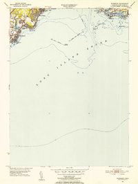 1951 Woodmont1952 Print · USGSThe Connecticut coast in the early fifties shows a burgeoning network of summer colonies and suburban expansions. Trace local history through landmarks like Savin Rock, Woodmont, and the historic New Haven Lighthouse.2 unique versions available
 - 1951 Map of Milford, 1953 Print
 1951 Milford1953 Print · USGSCoastal New Haven and Fairfield counties are shown in detail during the early fifties, capturing the growth of harbor towns and beach communities. Genealogists and historians can trace neighborhood roots through the Milford Cem, St Anns Sch, and the Bridgeport Municipal Airport.3 unique versions available
 - 1951 Map of Clinton, 1953 Print
 1951 Clinton1953 Print · USGSCoastal Connecticut in the early fifties shows a landscape of growing seaside communities and managed state forests. Researchers can trace the path of the New York New Haven and Hartford railroad or find historic local landmarks like the Cow Hill Red Sch and Evergreen Cem.3 unique versions available
 - 1952 Map of Middletown, 1954 Print
 1952 Middletown1954 Print · USGSThe Connecticut River valley thrives in the early fifties as Middletown and Portland expand around their industrial and academic roots. Genealogists and historians can locate Indian Hill Cemetery, the Swedish Orphanage, and the old Brazos Quarry.3 unique versions available
Showing maps 1-25 of 145
Top cities of South Central Connecticut Planning Region
- New Haven historical maps
- Meriden historical maps
- Hamden historical maps
- West Haven historical maps
- Milford historical maps
- Wallingford historical maps
See more
Frequently asked questions
- What are the different types of historical maps available for South Central Connecticut Planning Region?
- What is the oldest map of South Central Connecticut Planning Region?
- Where can I purchase historical maps of South Central Connecticut Planning Region for my home or office?
- Where can I download high-res historical maps of South Central Connecticut Planning Region?
- Are there historical topographic maps available for South Central Connecticut Planning Region?
- Is there historical aerial imagery available for South Central Connecticut Planning Region?
- Where are historical maps of South Central Connecticut Planning Region sourced from?