1960s Maps of South Central Connecticut Planning Region, Connecticut
Explore 17 historic maps of South Central Connecticut Planning Region from the 1960s. These maps offer a rare glimpse into what life looked like during the 1960s — showing old roads, neighborhoods, homes, and landmarks that have changed or disappeared over time.
Whether you're researching your family's past, planning a metal detecting trip, or studying how South Central Connecticut Planning Region's landscape evolved across the 1960s, these high-resolution maps are a powerful tool for exploring the history of this region.
- Focus on a specific era: All maps on this page are from the 1960s, giving you a focused view of this time period.
- See what’s changed: Compare century-old streets, trails, and buildings to today's modern landscape using overlays and satellite layers.
- Research with precision: Use these maps for genealogy, historical research, land use analysis, or educational projects.
- View, download, or print: Maps are fully viewable online in high resolution, and can be downloaded or printed for your own records.
Start exploring South Central Connecticut Planning Region's history through authentic maps from the 1960s. This is your window into the past.
South Central Connecticut Planning Region, CT maps
(17)- 1960 Map of Woodmont
 1960 Woodmont1960 Print · USGSThe Connecticut shoreline at the opening of the 1960s reveals a coastal landscape of growing suburban neighborhoods and vital maritime infrastructure. Researchers can trace the mid-century development of Woodmont and West Shore or locate shoreline landmarks like Savin Rock and the Southwest Ledge Lighthouse.3 unique versions available
 - 1960 Map of Milford
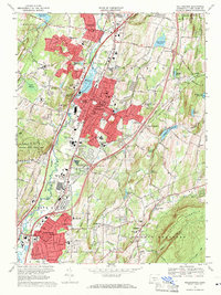
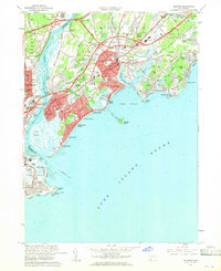 1960 Milford1960 Print · USGSThe Connecticut coastline was transforming in the early sixties as new turnpikes crossed historic harbor towns. Genealogists and local historians can trace the growth of neighborhoods from Devon to Morningside, locating family landmarks like Kings Cem or St Marys Ch.4 unique versions available
 - 1961 Map of Hartford
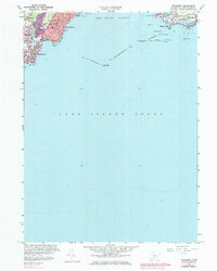
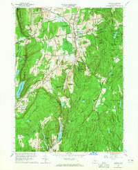
 1961 Hartford1961 Print · USGSSouthern New England and the Hudson Valley are shown here in the mid-fifties, capturing a landscape of booming coastal cities and interior hill towns. Researchers can trace the legacy of the New York New Haven and Hartford rail corridor and find strategic sites like Camp Shanks and Fort Michie.
 - 1961 Map of Haddam, 1964 Print
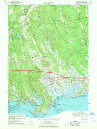
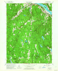 1961 Haddam1964 Print · USGSThe Lower Connecticut River Valley is shown here in the early sixties as a landscape of dense state forests and riverside hamlets. Genealogists and local historians can trace old family sites and burial grounds like Old Ponset Cem, Parker Hill Cem, and Emmanuel Ch.3 unique versions available
 - 1961 Map of Clinton, 1964 Print
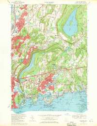
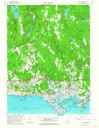 1961 Clinton1964 Print · USGSThe Connecticut shoreline transitions from salt marshes to forested hills in the early sixties. Genealogists and local historians can trace family-named sites like Roast Meat Hill, find St Marys Cem, and locate the old Griswold Airport.4 unique versions available
 - 1962 Map of Hartford, 1971 Print
 1962 Hartford1971 Print · USGSSouthern New England and the Hudson Valley are shown in the early sixties, as suburban growth reached into the foothills. Trace the path of the New York New Haven & Hartford RR and find landmarks like Camp Nathan Hale and Gillette Castle State Park.3 unique versions available
 - 1964 Map of Durham, 1965 Print
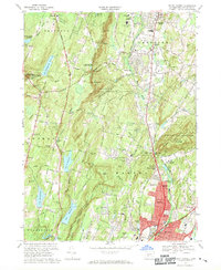
 1964 Durham1965 Print · USGSMid-century Middlesex County is captured here during a period of steady growth across the Durham uplands and the Cockaponset State Forest. Genealogists and local historians can trace family-named sites like Beaver Head Corner, Bluff Head Cem, and old district landmarks like Korn Sch.4 unique versions available
 - 1964 Map of Ansonia, 1967 Print
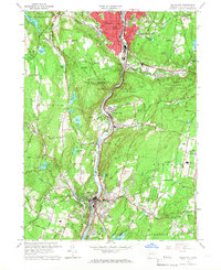
 1964 Ansonia1967 Print · USGSThe industrial Naugatuck Valley meets the emerging suburbs of New Haven County during the mid-sixties. Genealogists and historians can locate family-named landmarks like George's Cellar Hill or trace old burials at Riverside Cemetery and Turkey Hill Cem.4 unique versions available
 - 1964 Map of Naugatuck, 1967 Print
 1964 Naugatuck1967 Print · USGSThe Naugatuck Valley in the mid-1960s shows a landscape of dense riverside industry and steep wooded hills. Genealogists and historians can trace neighborhood landmarks like St Francis Ch, old burial grounds like St James Cem, and the path of the New Haven RR.6 unique versions available
 - 1965 Map of Hartford
 1965 Hartford1965 Print · USGSSouthern New England and the Hudson Valley are shown here during the mid-sixties expansion of the Interstate era. Trace the path of the New York New Haven & Hartford RR or locate historic landmarks like West Point Military Reservation and the Merritt Parkway.2 unique versions available
 - 1965 Map of Middletown, 1968 Print
 1965 Middletown1968 Print · USGSMiddletown and its riverfront neighbors are captured here in the mid-sixties, showcasing a landscape of academic prestige and industrial legacy. Genealogists and historians can trace institutional roots at Wesleyan University or find family markers in Indian Hill Cemetery and St Johns Cem.5 unique versions available
 - 1967 Map of New Haven, 1970 Print
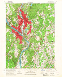
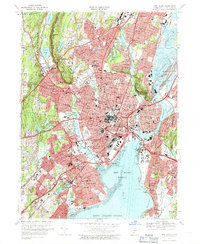 1967 New Haven1970 Print · USGSNew Haven and its neighboring towns appear here in the late sixties, showing a dense coastal city shaped by its famous university and river system. Genealogists can locate family sites near St Lawrence Cemetery, Spring Glen, or the Eli Whitney Technical Sch.5 unique versions available
 - 1967 Map of Meriden, 1970 Print
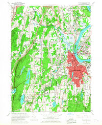
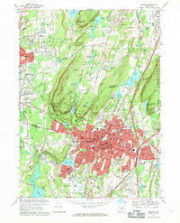 1967 Meriden1970 Print · USGSMeriden and Southington are shown in detail during the late sixties, a time of suburban expansion and industrial transition. Genealogists and historians can trace family roots through sites like Walnut Grove Cemetery and the Undercliff Sanatorium.6 unique versions available
 - 1967 Map of Branford, 1970 Print
 1967 Branford1970 Print · USGSCoastal Connecticut at the end of the sixties shows a landscape of growing suburban corridors and quiet rocky harbors. Genealogists and historians can trace family locations through numerous landmarks like All Saints Cemetery, Pine Orchard, and the scattered islands of The Thimbles.4 unique versions available
 - 1967 Map of Mount Carmel, 1970 Print
 1967 Mount Carmel1970 Print · USGSHamden and Cheshire are captured during a period of mid-century suburban expansion in New Haven County. Researchers can trace historic family plots at Old Bethany Cem, locate Quinnipiac College, and see the early layout of Sleeping Giant State Park.5 unique versions available
 - 1967 Map of Wallingford, 1971 Print
 1967 Wallingford1971 Print · USGSWallingford and the Quinnipiac River valley are shown here in the mid-sixties as post-war suburban growth met established industrial and medical institutions. Researchers can trace historic properties like Choate Sch, the Masonic Cem, and the Gaylord Farms Sanatorium.3 unique versions available
 - 1968 Map of Guilford, 1970 Print
 1968 Guilford1970 Print · USGSThe Connecticut shoreline in the late sixties reveals a landscape of rocky coastal islands and expanding post-war infrastructure. Trace family roots at St Johns Cem, explore the granite coast of Stony Creek, or locate the historic Guilford Sta.5 unique versions available
End of results
Showing maps 1-17 of 17
Top cities of South Central Connecticut Planning Region
- New Haven historical maps
- Meriden historical maps
- Hamden historical maps
- West Haven historical maps
- Milford historical maps
- Wallingford historical maps
See more
Frequently asked questions
- What are the different types of historical maps available for South Central Connecticut Planning Region?
- What is the oldest map of South Central Connecticut Planning Region?
- Where can I purchase historical maps of South Central Connecticut Planning Region for my home or office?
- Where can I download high-res historical maps of South Central Connecticut Planning Region?
- Are there historical topographic maps available for South Central Connecticut Planning Region?
- Is there historical aerial imagery available for South Central Connecticut Planning Region?
- Where are historical maps of South Central Connecticut Planning Region sourced from?