1950s Maps of Merwinsville, New Milford
Explore 2 historic maps of Merwinsville from the 1950s. These maps offer a rare glimpse into what life looked like during the 1950s — showing old roads, neighborhoods, homes, and landmarks that have changed or disappeared over time.
Whether you're researching your family's past, planning a metal detecting trip, or studying how Merwinsville's landscape evolved across the 1950s, these high-resolution maps are a powerful tool for exploring the history of this region.
- Focus on a specific era: All maps on this page are from the 1950s, giving you a focused view of this time period.
- See what’s changed: Compare century-old streets, trails, and buildings to today's modern landscape using overlays and satellite layers.
- Research with precision: Use these maps for genealogy, historical research, land use analysis, or educational projects.
- View, download, or print: Maps are fully viewable online in high resolution, and can be downloaded or printed for your own records.
Start exploring Merwinsville's history through authentic maps from the 1950s. This is your window into the past.
Merwinsville, New Milford maps
(2)- 1950 Map of Kent
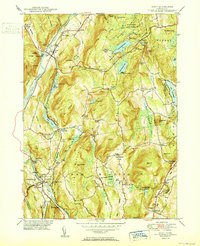 1950 Kent1950 Print · USGSWestern Connecticut's river valleys and ridgelines are captured here at mid-century, following the winding Housatonic River. Researchers can trace the New York New Haven and Hartford RR through Gaylordsville or locate Bulls Bridge and Kent Furnace.2 unique versions available
 - 1955 Map of Kent, 1956 Print
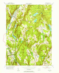 1955 Kent1956 Print · USGSLitchfield County in the mid-fifties is a landscape of river-valley towns and upland summer camps. Genealogists and historians can trace rail-era landmarks like Gaylordsville Sta and old burial grounds such as Kent Hollow Cem or Morningside Cem.4 unique versions available
End of results
Showing maps 1-2 of 2
Top cities near Merwinsville
- Danbury historical maps
- Carmel historical maps
- East Fishkill historical maps
- Southbury historical maps
- Bethel historical maps
- Southeast historical maps
See more
Frequently asked questions
- What are the different types of historical maps available for Merwinsville?
- What is the oldest map of Merwinsville?
- Where can I purchase historical maps of Merwinsville for my home or office?
- Where can I download high-res historical maps of Merwinsville?
- Are there historical topographic maps available for Merwinsville?
- Is there historical aerial imagery available for Merwinsville?
- Where are historical maps of Merwinsville sourced from?