1990s Maps of Thomas Cove, New Castle County
Explore 3 historic maps of Thomas Cove from the 1990s. These maps offer a rare glimpse into what life looked like during the 1990s — showing old roads, neighborhoods, homes, and landmarks that have changed or disappeared over time.
Whether you're researching your family's past, planning a metal detecting trip, or studying how Thomas Cove's landscape evolved across the 1990s, these high-resolution maps are a powerful tool for exploring the history of this region.
- Focus on a specific era: All maps on this page are from the 1990s, giving you a focused view of this time period.
- See what’s changed: Compare century-old streets, trails, and buildings to today's modern landscape using overlays and satellite layers.
- Research with precision: Use these maps for genealogy, historical research, land use analysis, or educational projects.
- View, download, or print: Maps are fully viewable online in high resolution, and can be downloaded or printed for your own records.
Start exploring Thomas Cove's history through authentic maps from the 1990s. This is your window into the past.
Thomas Cove, New Castle County maps
(3)- 1993 Map of Taylors Bridge
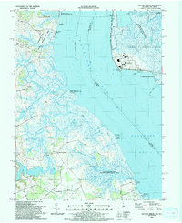 1993 Taylors Bridge1993 Print · USGSThe Delaware shoreline and tidal marshes are captured in the early 1990s as the Salem Nuclear Powerplant stands opposite historic rural landings. Researchers can trace local genealogy and land use through Taylors Bridge, old schools along Walker School Road, and the family-named Thomas Landing.
 - 1993 Map of Middletown
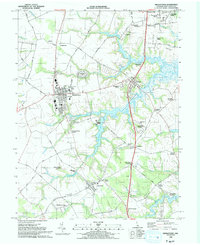 1993 Middletown1993 Print · USGSMiddletown and Townsend are shown in the early nineties as established Delaware communities surrounded by family-named crossroads and historic river landings. Genealogists can trace family names at Old Drawyers Cem, Forest Cem, and the riverside Blackbird Landing.
 - 1999 Map of Taylors Bridge, 2001 Print
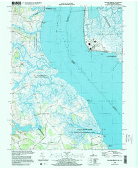 1999 Taylors Bridge2001 Print · USGSThe Delaware riverfront at the close of the century shows a unique mix of heavy industry and coastal preservation. Genealogists and researchers can trace family-named sites like Taylors Bridge, Thomas Landing, and Fennimore Landing alongside the Salem Nuclear Powerplant.
End of results
Showing maps 1-3 of 3
Frequently asked questions
- What are the different types of historical maps available for Thomas Cove?
- What is the oldest map of Thomas Cove?
- Where can I purchase historical maps of Thomas Cove for my home or office?
- Where can I download high-res historical maps of Thomas Cove?
- Are there historical topographic maps available for Thomas Cove?
- Is there historical aerial imagery available for Thomas Cove?
- Where are historical maps of Thomas Cove sourced from?