1960s Maps of Manns Spur, Florida
Explore 1 historic maps of Manns Spur from the 1960s. These maps offer a rare glimpse into what life looked like during the 1960s — showing old roads, neighborhoods, homes, and landmarks that have changed or disappeared over time.
Whether you're researching your family's past, planning a metal detecting trip, or studying how Manns Spur's landscape evolved across the 1960s, these high-resolution maps are a powerful tool for exploring the history of this region.
- Focus on a specific era: All maps on this page are from the 1960s, giving you a focused view of this time period.
- See what’s changed: Compare century-old streets, trails, and buildings to today's modern landscape using overlays and satellite layers.
- Research with precision: Use these maps for genealogy, historical research, land use analysis, or educational projects.
- View, download, or print: Maps are fully viewable online in high resolution, and can be downloaded or printed for your own records.
Start exploring Manns Spur's history through authentic maps from the 1960s. This is your window into the past.
Manns Spur, FL maps
(1)- 1963 Map of Sanderson South, 1964 Print
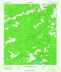 1963 Sanderson South1964 Print · USGSNorth Florida's timber and rail country is captured in the early sixties, showing the vital connection between the Osceola National Forest and the Seaboard Air Line. Genealogists can locate the Bethlehem Cem and trace early crossroads near Sanderson and Manns Spur.2 unique versions available
End of results
Showing maps 1-1 of 1
Top cities near Manns Spur
- Macclenny historical maps
- Lake Butler historical maps
- Glen Saint Mary historical maps
- Raiford historical maps
Frequently asked questions
- What are the different types of historical maps available for Manns Spur?
- What is the oldest map of Manns Spur?
- Where can I purchase historical maps of Manns Spur for my home or office?
- Where can I download high-res historical maps of Manns Spur?
- Are there historical topographic maps available for Manns Spur?
- Is there historical aerial imagery available for Manns Spur?
- Where are historical maps of Manns Spur sourced from?