1940s Maps of Malabar, Florida
Explore 2 historic maps of Malabar from the 1940s. These maps offer a rare glimpse into what life looked like during the 1940s — showing old roads, neighborhoods, homes, and landmarks that have changed or disappeared over time.
Whether you're researching your family's past, planning a metal detecting trip, or studying how Malabar's landscape evolved across the 1940s, these high-resolution maps are a powerful tool for exploring the history of this region.
- Focus on a specific era: All maps on this page are from the 1940s, giving you a focused view of this time period.
- See what’s changed: Compare century-old streets, trails, and buildings to today's modern landscape using overlays and satellite layers.
- Research with precision: Use these maps for genealogy, historical research, land use analysis, or educational projects.
- View, download, or print: Maps are fully viewable online in high resolution, and can be downloaded or printed for your own records.
Start exploring Malabar's history through authentic maps from the 1940s. This is your window into the past.
Malabar, FL maps
(2)- 1949 Map of Melbourne East, 1960 Print
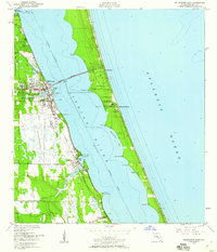 1949 Melbourne East1960 Print · USGSThe Florida coast near the mid-century shows a network of citrus and rail towns connected by the Melbourne Causeway. Genealogists and researchers can trace the early development of Eau Gallie, find the cemetery at Crane Creek, or locate the Ruins near Malabar.5 unique versions available
 - 1949 Map of Grant, 1968 Print
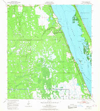 1949 Grant1968 Print · USGSThe Florida coastline between Malabar and Micco appears here just after the war, featuring the Valkaria Naval Air Station. Researchers can trace the Florida East Coast rail line through Grant and explore islands like Grant Farm Island.4 unique versions available
End of results
Showing maps 1-2 of 2
Top cities near Malabar
- Palm Bay historical maps
- Melbourne historical maps
- West Melbourne historical maps
- Sebastian historical maps
- Satellite Beach historical maps
- Micco historical maps
See more
Top neighborhoods of Malabar
- Southern Comfort historical maps
- Oakmont Preserve historical maps
- Weber Woods historical maps
- Rocky Point historical maps
- Twin Lakes historical maps
- Country Cove historical maps
See more
Frequently asked questions
- What are the different types of historical maps available for Malabar?
- What is the oldest map of Malabar?
- Where can I purchase historical maps of Malabar for my home or office?
- Where can I download high-res historical maps of Malabar?
- Are there historical topographic maps available for Malabar?
- Is there historical aerial imagery available for Malabar?
- Where are historical maps of Malabar sourced from?