1940s Maps of Pembroke Pines, Broward County
Explore 3 historic maps of Pembroke Pines from the 1940s. These maps offer a rare glimpse into what life looked like during the 1940s — showing old roads, neighborhoods, homes, and landmarks that have changed or disappeared over time.
Whether you're researching your family's past, planning a metal detecting trip, or studying how Pembroke Pines's landscape evolved across the 1940s, these high-resolution maps are a powerful tool for exploring the history of this region.
- Focus on a specific era: All maps on this page are from the 1940s, giving you a focused view of this time period.
- See what’s changed: Compare century-old streets, trails, and buildings to today's modern landscape using overlays and satellite layers.
- Research with precision: Use these maps for genealogy, historical research, land use analysis, or educational projects.
- View, download, or print: Maps are fully viewable online in high resolution, and can be downloaded or printed for your own records.
Start exploring Pembroke Pines's history through authentic maps from the 1940s. This is your window into the past.
Pembroke Pines, Broward County maps
(3)- 1947 Map of North Miami, 1959 Print
 1947 North Miami1959 Print · USGSCoastal Florida is shown in a period of significant post-war expansion between Hollywood and Miami Shores. Researchers can trace the layout of early communities and landmarks like the U S Naval Air Station, MacArthur Airport, and the Hollywood Kennel Club.
 - 1949 Map of Opalocka
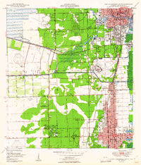
 1949 Opalocka1949 Print · USGSNorth Miami-Dade was a hub of military aviation and early suburban expansion in the years following World War II. Researchers can trace the layout of the U S Naval Air Station and several regional airfields like Master Field and Municipal Field.2 unique versions available
 - 1949 Map of Fort Lauderdale South
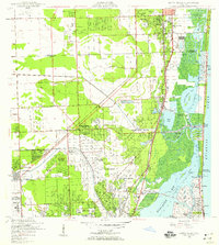
 1949 Fort Lauderdale South1949 Print · USGSSoutheast Florida’s coastal corridor comes into focus at mid-century, as the cities of Fort Lauderdale and Hollywood begin to expand inland. Genealogists and historians can trace local landmarks like the Seminole Ch, the Riverside Military Academy, and the Florida East Coast rail line.2 unique versions available
End of results
Showing maps 1-3 of 3
Frequently asked questions
- What are the different types of historical maps available for Pembroke Pines?
- What is the oldest map of Pembroke Pines?
- Where can I purchase historical maps of Pembroke Pines for my home or office?
- Where can I download high-res historical maps of Pembroke Pines?
- Are there historical topographic maps available for Pembroke Pines?
- Is there historical aerial imagery available for Pembroke Pines?
- Where are historical maps of Pembroke Pines sourced from?