1980s Maps of Altha, Florida
Explore 3 historic maps of Altha from the 1980s. These maps offer a rare glimpse into what life looked like during the 1980s — showing old roads, neighborhoods, homes, and landmarks that have changed or disappeared over time.
Whether you're researching your family's past, planning a metal detecting trip, or studying how Altha's landscape evolved across the 1980s, these high-resolution maps are a powerful tool for exploring the history of this region.
- Focus on a specific era: All maps on this page are from the 1980s, giving you a focused view of this time period.
- See what’s changed: Compare century-old streets, trails, and buildings to today's modern landscape using overlays and satellite layers.
- Research with precision: Use these maps for genealogy, historical research, land use analysis, or educational projects.
- View, download, or print: Maps are fully viewable online in high resolution, and can be downloaded or printed for your own records.
Start exploring Altha's history through authentic maps from the 1980s. This is your window into the past.
Altha, FL maps
(3)- 1982 Map of Altha East
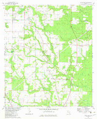 1982 Altha East1982 Print · USGSThe rural border of Jackson and Calhoun counties is captured here in the early 1980s as a landscape of timber and wetlands. Local historians can trace the foundations of Alliance and Macedonia or locate family sites like Barton Cem and Henderson Mill.
 - 1982 Map of Altha West, 1983 Print
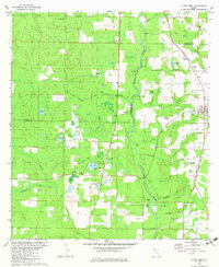 1982 Altha West1983 Print · USGSNorth Florida’s riverine landscape is captured here in the early eighties, centered on the Chipola River and the rural town of Altha. Local researchers can trace family landmarks like Ritchards Cem and Page Ch, or follow the path of the Old Railroad Grade.
 - 1988 Map of Tallahassee
 1988 Tallahassee1988 Print · USGSThe Florida Panhandle and South Georgia are captured here in the late eighties, showing the expansion of the regional highway network and coastal growth. Genealogists and historians can trace rail lines like the Seaboard System Railroad or locate family roots in Blountstown, Graceville, or Crawfordville.2 unique versions available
End of results
Showing maps 1-3 of 3
Top cities near Altha
- Marianna historical maps
- Blountstown historical maps
- Sneads historical maps
- Bristol historical maps
- Cottondale historical maps
- Grand Ridge historical maps
Frequently asked questions
- What are the different types of historical maps available for Altha?
- What is the oldest map of Altha?
- Where can I purchase historical maps of Altha for my home or office?
- Where can I download high-res historical maps of Altha?
- Are there historical topographic maps available for Altha?
- Is there historical aerial imagery available for Altha?
- Where are historical maps of Altha sourced from?