1900s (20th Century) Maps of Leno, Florida
Explore 8 historic maps of Leno from the 1900s (20th Century). These maps offer a rare glimpse into what life looked like during the 1900s — showing old roads, neighborhoods, homes, and landmarks that have changed or disappeared over time.
Whether you're researching your family's past, planning a metal detecting trip, or studying how Leno's landscape evolved across the 1900s, these high-resolution maps are a powerful tool for exploring the history of this region.
- Focus on a specific era: All maps on this page are from the 1900s, giving you a focused view of this time period.
- See what’s changed: Compare century-old streets, trails, and buildings to today's modern landscape using overlays and satellite layers.
- Research with precision: Use these maps for genealogy, historical research, land use analysis, or educational projects.
- View, download, or print: Maps are fully viewable online in high resolution, and can be downloaded or printed for your own records.
Start exploring Leno's history through authentic maps from the 1900s. This is your window into the past.
Leno, FL maps
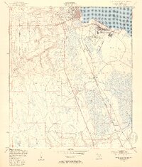
(8)- 1947 Map of Bostwick
 1947 Bostwick1947 Print · USGSThe Saint Johns River valley in the late 1940s reveals a landscape defined by its waterways and timber-era rail lines. Researchers can trace historic river access at Clay Landing and Picolata, or follow the Atlantic Coast Line through Bostwick.
 - 1949 Map of Green Cove Springs, 1953 Print
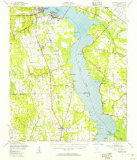
 1949 Green Cove Springs1953 Print · USGSGreen Cove Springs sits at a post-war crossroads where military installations and river life meet. Genealogists and historians can trace the footprint of the U S Naval Station alongside local landmarks like Hickory Grove Ch and Walkill.5 unique versions available
 - 1949 Map of Bostwick, 1955 Print
 1949 Bostwick1955 Print · USGSThe St. Johns River corridor comes to life in the late 1940s, showing a landscape of military installations and quiet river landings. Researchers can trace family roots at Shiloh Ch or Bostwick, and locate vanished river hubs like Picolata and Tocoi.
 - 1954 Map of Daytona Beach, 1974 Print
 1954 Daytona Beach1974 Print · USGSNortheast Florida is captured in the mid-1950s, showing the transition from river-based commerce to coastal tourism. Researchers can trace the Florida East Coast rail lines and find historic sites like Castillo de San Marcos Nat Mon and Palatka.
 - 1958 Map of Daytona Beach
 1958 Daytona Beach1958 Print · USGSThe Florida coast and St. Johns River valley are captured in the late 1950s, showing a landscape defined by citrus-belt rail towns and Atlantic shorelines. Genealogists can trace family roots through riverside settlements like Palatka and Welaka or coastal hubs like Daytona Beach.2 unique versions available
 - 1964 Map of Daytona Beach
 1964 Daytona Beach1964 Print · USGSCoastal Florida in the mid-1960s shows a fascinating balance between burgeoning beach tourism and the deep interior wilderness of the Ocala National Forest. Researchers can trace the path of the Florida East Coast railway through historic settlements like St. Augustine, Marineland, and Palatka.
 - 1981 Map of Saint Augustine, 1982 Print
 1981 Saint Augustine1982 Print · USGSNortheast Florida in the early eighties shows a landscape of deep river commerce and coastal growth. Genealogists and historians can trace the inland rail network of the Seaboard Coast Line through rural Hastings or explore the military footprint of Camp Blanding.2 unique versions available
 - 1991 Map of Green Cove Springs
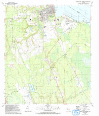 1991 Green Cove Springs1991 Print · USGSGreen Cove Springs and the surrounding Clay County riverfront are captured here in the early 1990s as the landscape balanced small-town life with industrial growth. Researchers can locate several burial grounds and schools, from Hickory Grove Cemetery to Bennett School, and trace the route of the Old Railroad Grade.
End of results
Showing maps 1-8 of 8
Top cities near Leno
- Jacksonville historical maps
- Fruit Cove historical maps
- Middleburg historical maps
- Palatka historical maps
- Green Cove Springs historical maps
- Hastings historical maps
See more
Frequently asked questions
- What are the different types of historical maps available for Leno?
- What is the oldest map of Leno?
- Where can I purchase historical maps of Leno for my home or office?
- Where can I download high-res historical maps of Leno?
- Are there historical topographic maps available for Leno?
- Is there historical aerial imagery available for Leno?
- Where are historical maps of Leno sourced from?