
1947 Map of Bostwick
USGS Topo · Published 1947About this map
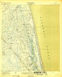
The Saint Johns River dominates this mid-century portrait of the Florida interior, serving as the primary geographic divider between Clay, Putnam, and Saint Johns counties. Along its western bank, the Atlantic Coast Line railroad dictates the placement of settlements like Bostwick, Leno, and Walkill, illustrating the era's reliance on rail for the transport of local goods. The river shoreline is densely packed with named points and historical river access sites, including Magnolia Landing, Clay Landing, and Lane Landing, which reflect a legacy of water-based commerce before the full dominance of modern highways. To the north, Green Cove Springs appears as a primary regional hub, connected eastward across the water by the Shands Bridge. The map captures a landscape transitioning from traditional river-and-rail dependency toward a more integrated road network, including Governors Road and Tocoi Road.
Find a feature on this map
55 named features on this map. Tap any name to fly to it.
Don’t see what you’re looking for? This feature index may not catch every label — zoom into the map to look around manually.
Map Details
Editions of this 1947 Bostwick Map
This is the sole edition of this map. No revisions or reprints were ever made.
Other maps of this area

1912 · Palatka
USGS Topo · 1:48,000

1915 · Palatka
USGS Topo · 1:62,500

1915 · Interlachen
USGS Topo · 1:48,000

1916 · Interlachen
USGS Topo · 1:62,500

1917 · Orange Park
USGS Topo · 1:62,500

1918 · Middleburg
USGS Topo · 1:62,500

1918 · Orange Park
USGS Topo · 1:62,500
1918 · Palm Valley
USGS Topo · 1:62,500

1937 · Bakersville
USGS Topo · 1:24,000

1937 · Elkton
USGS Topo · 1:24,000