
1912 Map of Palatka
USGS Topo · Published 1912About this map
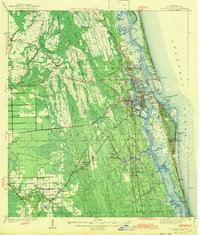
St Johns River serves as the central artery of this region, winding past Palatka and East Palatka at a time when the waterway was a primary thoroughfare. The river is lined with distinctive points like Forresters Pt and Wherstone Pt, indicating the importance of the Steamboat Route for regional commerce. To the south, Murphys Island and the expansive Rice Creek Swamp characterize the lowland terrain, while the heights at Satsuma Heights and Palatka Heights offer a contrast in elevation.
Find a feature on this map
82 named features on this map. Tap any name to fly to it.
Don’t see what you’re looking for? This feature index may not catch every label — zoom into the map to look around manually.
Map Details
Editions of this 1912 Palatka Map
This is the sole edition of this map. No revisions or reprints were ever made.
Other maps of this area

1915 · Palatka
USGS Topo · 1:62,500

1915 · Interlachen
USGS Topo · 1:48,000

1916 · Interlachen
USGS Topo · 1:62,500

1937 · Elkton
USGS Topo · 1:24,000

1937 · Dinner Island
USGS Topo · 1:48,000

1942 · Ates Creek
USGS Topo · 1:62,500
1943 · St. Augustine
USGS Topo · 1:62,500

1943 · Dinner Island
USGS Topo · 1:62,500

1944 · Dinner Island
USGS Topo · 1:62,500
1944 · Interlachen
USGS Topo · 1:62,500