1944 Map of Interlachen
USGS Topo · Published 1944About this map
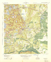
The town of Interlachen sits at the center of a dense cluster of lakes and ponds during the mid-1940s, serving as a hub for both the Atlantic Coast Line and Southern Railway. To the north, the settlement of Florahome marks the edge of the wetlands, while the southern boundary is defined by the Ocala National Forest and the northern reaches of Orange Springs. The map reveals a transition from the structured rail corridors of the north to the river-dependent landings of the south along the river.
Find a feature on this map
96 named features on this map. Tap any name to fly to it.
Don’t see what you’re looking for? This feature index may not catch every label — zoom into the map to look around manually.
Map Details
Editions of this 1944 Interlachen Map
This is the sole edition of this map. No revisions or reprints were ever made.
Other maps of this area

1893 · Citra
USGS Topo · 1:62,500

1895 · Citra
USGS Topo · 1:62,500

1912 · Palatka
USGS Topo · 1:48,000

1915 · Palatka
USGS Topo · 1:62,500

1915 · Interlachen
USGS Topo · 1:48,000

1916 · Interlachen
USGS Topo · 1:62,500

1938 · Hawthorn
USGS Topo · 1:48,000

1941 · Starke
USGS Topo · 1:62,500

1942 · Ates Creek
USGS Topo · 1:62,500

1943 · Hawthorn
USGS Topo · 1:62,500