
1937 Map of Dinner Island
USGS Topo · Published 1937About this map
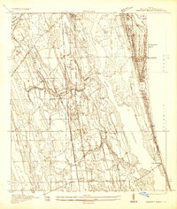
Big Fish-tatt Swamp dominates the central portion of this 1930s landscape, illustrating a complex network of wetlands and hummocks where ST. Johns County meets Flagler County. The mapping, conducted by W. H. Cullum and W. E. Noble, reveals a region defined by its island-like high ground, including Gopher Ridge, Turkey Island, and Myrtle Island. These features rise out of the swampy terrain, providing the foundation for early transport routes and small settlements.
Find a feature on this map
34 named features on this map. Tap any name to fly to it.
Don’t see what you’re looking for? This feature index may not catch every label — zoom into the map to look around manually.
Map Details
Editions of this 1937 Dinner Island Map
This is the sole edition of this map. No revisions or reprints were ever made.
Other maps of this area

1912 · Palatka
USGS Topo · 1:48,000

1915 · Palatka
USGS Topo · 1:62,500

1927 · Matanzas
USGS Topo · 1:48,000

1937 · Elkton
USGS Topo · 1:24,000
1937 · Crescent Beach
USGS Topo · 1:24,000

1937 · Ormond
USGS Topo · 1:48,000
1943 · St. Augustine
USGS Topo · 1:62,500

1943 · Dinner Island
USGS Topo · 1:62,500

1943 · Matanzas
USGS Topo · 1:62,500

1944 · Ormond
USGS Topo · 1:62,500